
IMAGES TAKEN NEAR TO
Minerva Way, GLASGOW, G3 8AT
Introduction
This page details the photographs taken nearby to Minerva Way, G3 8AT by members of the Geograph project.
The Geograph project started in 2005 with the aim of publishing, organising and preserving representative images for every square kilometre of Great Britain, Ireland and the Isle of Man.

There are currently over 7.5m images from over14,400 individuals and you can help contribute to the project by visiting https://www.geograph.org.uk
Image Map
Images are licensed for reuse under creativecommons.org/licenses/by-sa/2.0
Notes
- Clicking on the map will re-center to the selected point.
- The higher the marker number, the further away the image location is from the centre of the postcode.
Image Listing (410 Images Found)
Images are licensed for reuse under creativecommons.org/licenses/by-sa/2.0
Image
Details
Distance
1
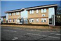
Finnieston Business Park
One of the business units on Minerva Way.
Image: © Richard Sutcliffe
Taken: 17 Apr 2019
0.03 miles
2
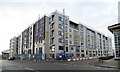
G3 Square
A new apartment building under construction at the corner of Minerva Street and Minerva Way. This was previously the site of a car dealership.
Image: © Thomas Nugent
Taken: 5 Jan 2021
0.03 miles
3
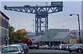
Minerva Street and the Finnieston Crane
The Finnieston Crane dominates the scene, with Exhibition Centre railway station and the covered walkway to the SECC also visible.
Image: © Thomas Nugent
Taken: 10 Oct 2010
0.04 miles
4
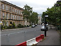
St Vincent Crescent
Looking towards Minerva Street.
Image: © Richard Sutcliffe
Taken: 16 Jun 2015
0.04 miles
5
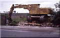
Flattened weighbridge building
The machine is sitting on top of a pile of rubble - all that remains of Public Weighbridge No 1 on St Vincent Crescent. It was being demolished in preparation for building on what is today Minerva Way. The actual weighbridge can be seen in the foreground. In the far distance is the Finnieston Crane.
Up until 1960 the area behind the weighbridge was Stobcross Goods and Mineral Yard, with many railway sidings.
Scanned from a Kodachrome colour reversal (slide) film.
Image: © Richard Sutcliffe
Taken: Unknown
0.05 miles
6
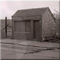
Public Weighbridge No 1
Weighbridge on St Vincent Crescent. It was later demolished in preparation for building on what is today Minerva Way Image
Up until 1960 the area behind the weighbridge was Stobcross Goods and Mineral Yard, with many railway sidings.
Image: © Richard Sutcliffe
Taken: 1 Jan 1983
0.05 miles
7
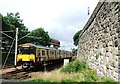
Train leaving Exhibition Centre station
A west bound train leaving Exhibition Centre station. Part of the covered walkway to the Scottish Exhibition and Conference Centre (SECC) can be seen overhead.
Exhibition Centre is the next station west of Anderston Image on the Argyle line. This station was originally named Stobcross and then changed to Finnieston when the Argyle line reopened in 1979, before being changed to Exhibition Centre in 1986.
Image: © Thomas Nugent
Taken: 14 Jul 2007
0.05 miles
8
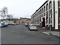
Minerva Street, Glasgow
Just outside Exhibition Centre Station.
Image: © Stephen Sweeney
Taken: 19 Jan 2008
0.05 miles
9
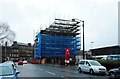
Building under construction, Minerva Street
Image: © Richard Sutcliffe
Taken: 26 Feb 2017
0.05 miles
10
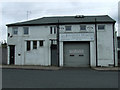
Jonathan Harvey Funeral Director
On Minerva Street.
Image: © Thomas Nugent
Taken: 8 Apr 2012
0.05 miles