IMAGES TAKEN NEAR TO
Commonhead Road, GLASGOW, G34 0DS
Introduction
This page details the photographs taken nearby to Commonhead Road, G34 0DS by members of the Geograph project.
The Geograph project started in 2005 with the aim of publishing, organising and preserving representative images for every square kilometre of Great Britain, Ireland and the Isle of Man.

There are currently over 7.5m images from over14,400 individuals and you can help contribute to the project by visiting https://www.geograph.org.uk
Image Map
Images are licensed for reuse under creativecommons.org/licenses/by-sa/2.0
Notes
- Clicking on the map will re-center to the selected point.
- The higher the marker number, the further away the image location is from the centre of the postcode.
Image Listing (3 Images Found)
Images are licensed for reuse under creativecommons.org/licenses/by-sa/2.0
Image
Details
Distance
1
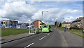
Lochdochart Road, Easterhouse
An X19 bus passes a new MUGA in a very much rebuilt Easterhouse.
Image: © Richard Webb
Taken: 23 Apr 2012
0.15 miles
2
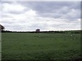
Commonhead Enclosure
Surrounded on two sides by roads and on the other by a burn this field was one of the first in Old Monkland parish to be 'enclosed' in the 'Agricultural Revolution' of the late 18th. and early 19th. centuries.
Image: © Robert Murray
Taken: 13 May 2010
0.19 miles
3
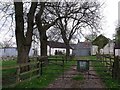
Commonhead Farm
On the edge of the urban sprawl it is now derelict and up for sale. For 150 years owned and farmed by successive generations of the Mason family.
Image: © Robert Murray
Taken: 13 May 2010
0.22 miles