IMAGES TAKEN NEAR TO
Auchan Crescent, GLASGOW, G33 6PE
Introduction
This page details the photographs taken nearby to Auchan Crescent, G33 6PE by members of the Geograph project.
The Geograph project started in 2005 with the aim of publishing, organising and preserving representative images for every square kilometre of Great Britain, Ireland and the Isle of Man.

There are currently over 7.5m images from over14,400 individuals and you can help contribute to the project by visiting https://www.geograph.org.uk
Image Map
Images are licensed for reuse under creativecommons.org/licenses/by-sa/2.0
Notes
- Clicking on the map will re-center to the selected point.
- The higher the marker number, the further away the image location is from the centre of the postcode.
Image Listing (8 Images Found)
Images are licensed for reuse under creativecommons.org/licenses/by-sa/2.0
Image
Details
Distance
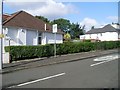
1
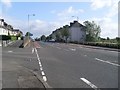
Cumbernauld Road
Main road between Cumbernauld and Glasgow, pictured here as it passes through Stepps.
Image: © Stephen Sweeney
Taken: 9 Sep 2009
0.13 miles
2
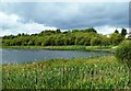
Frankfield Loch
A nice little nature spot on the edge of Glasgow.
Image: © Mary and Angus Hogg
Taken: 21 Aug 2019
0.16 miles
3
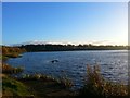
Frankfield Loch
The source of the Molendinar Burn.
Image: © Robert Murray
Taken: 24 Oct 2015
0.17 miles
4
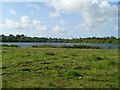
Frankfield Loch
Just south of Stepps.
Image: © Stephen Sweeney
Taken: 9 Sep 2009
0.18 miles
6
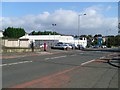
Somerfield, Stepps
Supermarket just off Cumbernauld Road.
Image: © Stephen Sweeney
Taken: 9 Sep 2009
0.22 miles
7
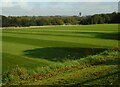
Playing fields
Looking across some of the University of Strathclyde's Stepps Playing Fields, towards the distinctive Buchanan Tower at Stepps.
Image: © Richard Sutcliffe
Taken: 29 Sep 2020
0.23 miles
8
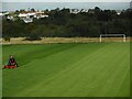
Grass cutting
Keeping the football pitches neat and tidy at the University of Strathclyde's Stepps Playing Fields.
Image: © Richard Sutcliffe
Taken: 29 Sep 2020
0.23 miles