IMAGES TAKEN NEAR TO
Second Avenue, GLASGOW, G33 6JS
Introduction
This page details the photographs taken nearby to Second Avenue, G33 6JS by members of the Geograph project.
The Geograph project started in 2005 with the aim of publishing, organising and preserving representative images for every square kilometre of Great Britain, Ireland and the Isle of Man.

There are currently over 7.5m images from over14,400 individuals and you can help contribute to the project by visiting https://www.geograph.org.uk
Image Map
Images are licensed for reuse under creativecommons.org/licenses/by-sa/2.0
Notes
- Clicking on the map will re-center to the selected point.
- The higher the marker number, the further away the image location is from the centre of the postcode.
Image Listing (10 Images Found)
Images are licensed for reuse under creativecommons.org/licenses/by-sa/2.0
Image
Details
Distance
1
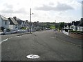
Looking down Third Avenue
Towards Cumbernauld Road.
Image: © Stephen Sweeney
Taken: 9 Sep 2009
0.05 miles
2
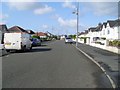
Fourth Avenue
In Stepps, on the edge of Glasgow.
Image: © Stephen Sweeney
Taken: 9 Sep 2009
0.06 miles
3
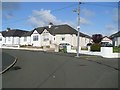
Third Avenue meets Fourth Avenue
Confluence of two streets in a residential area of Stepps.
Image: © Stephen Sweeney
Taken: 9 Sep 2009
0.07 miles
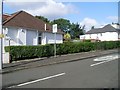
5
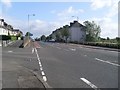
Cumbernauld Road
Main road between Cumbernauld and Glasgow, pictured here as it passes through Stepps.
Image: © Stephen Sweeney
Taken: 9 Sep 2009
0.21 miles
6
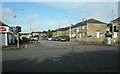
Station Road
Looking across the junction with Cumbernauld Road.
Image: © Richard Sutcliffe
Taken: 29 Sep 2020
0.23 miles
7
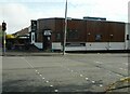
Dug 'n' Duck
Public bar at the corner of Cumbernauld Road and Avenue End Road.
Image: © Richard Sutcliffe
Taken: 29 Sep 2020
0.23 miles
8
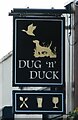
Sign for the Dug 'n' Duck
Public bar Image
Image: © Richard Sutcliffe
Taken: 29 Sep 2020
0.23 miles
9
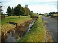
Molendinar Burn
The burn flows from Frankfield Loch to Hogganfield Loch and then through Glasgow and on to the River Clyde. For most of its length, the burn is culverted. This section, although flowing in an un-natural straight channel, is one of the few places the burn can actually be seen.
Image: © Richard Sutcliffe
Taken: 29 Sep 2020
0.23 miles
10
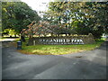
Entrance to Hogganfield Park
This is the entrance at the corner of Cumbernauld Road and Avenue End Road. It is one of the gateways to the larger Seven Lochs Wetland Park, which also includes Frankfield Loch, Bishop Loch, Johnston Loch, Woodend Loch, Lochend Loch and Garnqueen Loch.
Image: © Richard Sutcliffe
Taken: 29 Sep 2020
0.25 miles