IMAGES TAKEN NEAR TO
Easter Queenslie Road, GLASGOW, G33 4UL
Introduction
This page details the photographs taken nearby to Easter Queenslie Road, G33 4UL by members of the Geograph project.
The Geograph project started in 2005 with the aim of publishing, organising and preserving representative images for every square kilometre of Great Britain, Ireland and the Isle of Man.

There are currently over 7.5m images from over14,400 individuals and you can help contribute to the project by visiting https://www.geograph.org.uk
Image Map
Images are licensed for reuse under creativecommons.org/licenses/by-sa/2.0
Notes
- Clicking on the map will re-center to the selected point.
- The higher the marker number, the further away the image location is from the centre of the postcode.
Image Listing (10 Images Found)
Images are licensed for reuse under creativecommons.org/licenses/by-sa/2.0
Image
Details
Distance
1
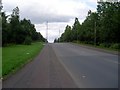
Easter Queenslie Road
Road into the eastern end of Queenslie Industrial Estate.
Image: © Stephen Sweeney
Taken: 16 Aug 2008
0.09 miles
2
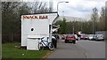
Snack bar, Easter Queenslie Road
An industrial estate (always a good bet for a cup of tea) just off the M8. There is a waste handling facility to the right.
Image: © Richard Webb
Taken: 23 Apr 2012
0.16 miles
3
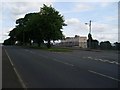
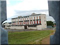
Wellhouse Primary School
From Bartiebeith Road.
Image: © Stephen Sweeney
Taken: 16 Aug 2008
0.17 miles
4
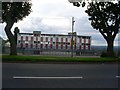
Wellhouse Primary School
Seen from Bartiebeith Road.
Image: © Stephen Sweeney
Taken: 16 Aug 2008
0.20 miles
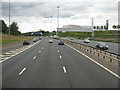
6
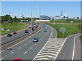
M8 near Glasgow Fort
Looking west along the M8 at Junction 10 towards the Glasgow Fort Shopping Centre.
Image: © G Laird
Taken: 30 May 2009
0.21 miles
7
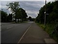
Looking downhill on Bartiebeith Road
Image: © Stephen Sweeney
Taken: 16 Aug 2008
0.22 miles
8
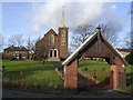
St John Ogilvie, Roman Catholic Church
On Newhills Road / Wellhouse Crescent, Easterhouse
Image: © Chris Upson
Taken: 17 Feb 2006
0.23 miles
9
The M8 by Glasgow Fort
Looking west to the shopping complex.
Image: © M J Richardson
Taken: 24 Aug 2013
0.23 miles
10
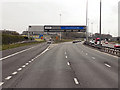
M8 Motorway at Junction 10
Sign gantry and exit slip road at junction 10 of the M8 motorway.
Note the typical “Glasgow-type” sign gantry with the following distinctive elements:
• Near and offside support legs (basically 2 rectangular hollow sections with base plates to allow connections to the foundations)
• A Main Frame (made up of rectangular hollow sections) - Over clad on the front and rear.
• A Sub Frame (made up of smaller hollow sections and welded to main frame).
• A Sign Face - acrylic sheets hung from the front of the sub frame over its full height.
• Internal Electrics - sign lighting provided through the use of several dozen fluorescent battens.
Gantries of this type were erected as part of the construction of the Kingston Bridge and its approach roads in 1970 and they are now a familiar sight on the network around Glasgow.
More information on “Glasgow Style Gantries” at http://www.glasgows-motorways.co.uk/glasgow-gantries/4578281645 (Glasgow’s Motorways)
Image: © David Dixon
Taken: 20 Apr 2012
0.25 miles