IMAGES TAKEN NEAR TO
Gartloch Road, GLASGOW, G33 3TH
Introduction
This page details the photographs taken nearby to Gartloch Road, G33 3TH by members of the Geograph project.
The Geograph project started in 2005 with the aim of publishing, organising and preserving representative images for every square kilometre of Great Britain, Ireland and the Isle of Man.

There are currently over 7.5m images from over14,400 individuals and you can help contribute to the project by visiting https://www.geograph.org.uk
Image Map
Images are licensed for reuse under creativecommons.org/licenses/by-sa/2.0
Notes
- Clicking on the map will re-center to the selected point.
- The higher the marker number, the further away the image location is from the centre of the postcode.
Image Listing (11 Images Found)
Images are licensed for reuse under creativecommons.org/licenses/by-sa/2.0
Image
Details
Distance
1
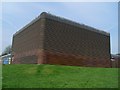
Unusual building by Gartloch Road
Surprisingly, this is a community centre.
Image: © Stephen Sweeney
Taken: 20 Apr 2009
0.02 miles
2
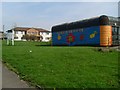
Ruchazie Community Centre
Unusual building for a Community Centre. Viewed from Gartloch Road.
Image: © Stephen Sweeney
Taken: 20 Apr 2009
0.02 miles
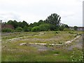
3
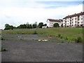
Site of a school, Ruchazie
The playground, next to a levelled site where the building once stood.
Image: © Richard Webb
Taken: 16 Jun 2011
0.05 miles
4
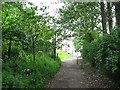
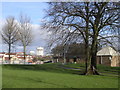
Path, Hogganfield Park
The path links Hogganfield Loch with Ruchazie. The security fence on the left protects a large covered reservoir, and the one on the right surrounds a golf course.
Image: © Richard Webb
Taken: 16 Jun 2011
0.06 miles
5
Site of a school, Ruchazie
The site of the building.
Image: © Richard Webb
Taken: 16 Jun 2011
0.08 miles
6
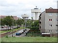
Boghall Street, Ruchazie
Eastward view towards Craigend and Garthamlock water towers.
Image: © Richard Webb
Taken: 16 Jun 2011
0.09 miles
7
Boghall Street, Ruchazie
A street with few surviving buildings. The school has gone (right).
Image: © Richard Webb
Taken: 16 Jun 2011
0.11 miles
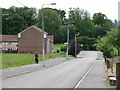
8
Gartloch Road
With the Garthamlock water towers dominating the scene.
Image: © Thomas Nugent
Taken: 17 Jun 2018
0.12 miles
9
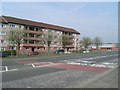
Flats on Galdenoch Street
From Avenue End Road.
Image: © Stephen Sweeney
Taken: 20 Apr 2009
0.18 miles
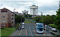
10
Elmcroft Nursery School
The nursery school is on the right, with the Craigend and Garthamlock Water Towers in the distance
Image: © Chris Upson
Taken: 17 Feb 2006
0.20 miles