IMAGES TAKEN NEAR TO
Cumbernauld Road, GLASGOW, G33 2ET
Introduction
This page details the photographs taken nearby to Cumbernauld Road, G33 2ET by members of the Geograph project.
The Geograph project started in 2005 with the aim of publishing, organising and preserving representative images for every square kilometre of Great Britain, Ireland and the Isle of Man.

There are currently over 7.5m images from over14,400 individuals and you can help contribute to the project by visiting https://www.geograph.org.uk
Image Map
Images are licensed for reuse under creativecommons.org/licenses/by-sa/2.0
Notes
- Clicking on the map will re-center to the selected point.
- The higher the marker number, the further away the image location is from the centre of the postcode.
Image Listing (20 Images Found)
Images are licensed for reuse under creativecommons.org/licenses/by-sa/2.0
Image
Details
Distance
1
Cumbernauld Road at Edinburgh Road
Major road junction in the East End of Glasgow.
Image: © Stephen Sweeney
Taken: 21 Apr 2009
0.05 miles
2
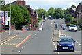
Cumbernauld Road
Climbing up the hill from Alexandra Parade. The red brick wall on the left is a bridge over the disused Caledonian Railway "Switchback Line" https://en.wikipedia.org/wiki/The_Switchback which connected Rutherglen to the north east of the city.
Image: © Thomas Nugent
Taken: 17 Jun 2018
0.06 miles
3
Edinburgh Road crosses dismantled railway
Between Haghill and Carntyne.
Image: © Stephen Sweeney
Taken: 21 Apr 2009
0.06 miles
4
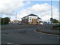
Junction of A8 and A80
Looking east along Cumbernauld Road (A8) to the junction where Cumbernauld Road continues to the left as the A80 while the A8 continues straight through as Edinburgh Road.
In the days before the M8 bypassed this junction, for most of the day this was extremely congested often taking a long time to travel along Alexandra Parade and Cumbernauld Road to this junction.
Image: © G Laird
Taken: 28 Mar 2009
0.07 miles
5
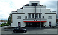
Vogue Bingo Hall
The former Riddrie Picture House on Cumbernauld Road, designed by James McKissack of John McKissack & Son, opened 1938. Regarded as an outstanding example of an Art Deco cinema. Category B Listed http://portal.historicenvironment.scot/designation/LB51104 .
Image: © Thomas Nugent
Taken: 17 Jun 2018
0.11 miles
6
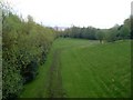
Dismantled railway route, Haghill
From Edinburgh Road.
Image: © Stephen Sweeney
Taken: 21 Apr 2009
0.11 miles
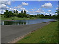
8
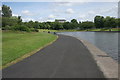
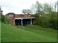
The pond, Alexandra Park
The far end of the pond has had the edges 'naturalised', making it more attractive for wildlife.
Image: © Richard Sutcliffe
Taken: 7 Jul 2016
0.15 miles
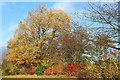
9
Alexandra Park
Dennistoun benefits from a large Victorian park. The Park takes its name from Princess Alexandra, the wife of the future King Edward VII, who officially opened the Park in 1870. The park was established in 1866 when the City Improvement Trustees purchased the park from Mr. Walter Stewart of Haghill. Mr. Alexander Dennistoun, the proprietor of the adjoining estate of Golfhill, later gifted five acres of land to the City Improvement Trustees.
Image: © George Rankin
Taken: 20 May 2007
0.15 miles
10
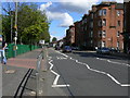
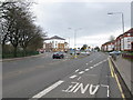
Cumbernauld Road, Dennistoun
View of Cumbernauld Road from entrance to Haghill Community Centre looking east. Dennistoun is a large district in the city of Glasgow. It is situated north of the River Clyde in the east end of the city.
Image: © George Rankin
Taken: 20 May 2007
0.15 miles