IMAGES TAKEN NEAR TO
Bideford Crescent, GLASGOW, G32 9NQ
Introduction
This page details the photographs taken nearby to Bideford Crescent, G32 9NQ by members of the Geograph project.
The Geograph project started in 2005 with the aim of publishing, organising and preserving representative images for every square kilometre of Great Britain, Ireland and the Isle of Man.

There are currently over 7.5m images from over14,400 individuals and you can help contribute to the project by visiting https://www.geograph.org.uk
Image Map
Images are licensed for reuse under creativecommons.org/licenses/by-sa/2.0
Notes
- Clicking on the map will re-center to the selected point.
- The higher the marker number, the further away the image location is from the centre of the postcode.
Image Listing (10 Images Found)
Images are licensed for reuse under creativecommons.org/licenses/by-sa/2.0
Image
Details
Distance
1
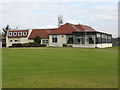
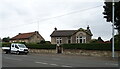
Sandyhills Golf Club - Clubhouse
The course was founded in 1905 on the lands of Sandyhills, Shettleston. The clubhouse and the course were officially opened on Saturday 5th May 1906.
Image: © G Laird
Taken: 13 Feb 2010
0.19 miles
2
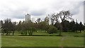
Sandyhills Golf Club
A parkland golf course, Mount Vernon.
Image: © Richard Webb
Taken: 23 Apr 2012
0.21 miles
3

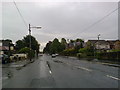
Private road to Sandyhills Golf Club
Image: © Stephen Sweeney
Taken: 30 Apr 2009
0.22 miles
4
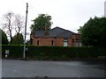
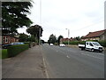
House on Hamilton Road
Viewed from Woodend Road to the east of the property.
Image: © Stephen Sweeney
Taken: 30 Apr 2009
0.23 miles
5
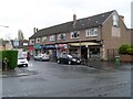
Mount Vernon shops
On Central Avenue.
Image: © Stephen Sweeney
Taken: 30 Apr 2009
0.23 miles
6
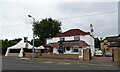
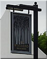
The Woodend, Mount Vernon
On Hamilton Road.
Image: © JThomas
Taken: 13 Sep 2021
0.24 miles