IMAGES TAKEN NEAR TO
Colliery Gate, GLASGOW, G32 8RH
Introduction
This page details the photographs taken nearby to Colliery Gate, G32 8RH by members of the Geograph project.
The Geograph project started in 2005 with the aim of publishing, organising and preserving representative images for every square kilometre of Great Britain, Ireland and the Isle of Man.

There are currently over 7.5m images from over14,400 individuals and you can help contribute to the project by visiting https://www.geograph.org.uk
Image Map
Images are licensed for reuse under creativecommons.org/licenses/by-sa/2.0
Notes
- Clicking on the map will re-center to the selected point.
- The higher the marker number, the further away the image location is from the centre of the postcode.
Image Listing (24 Images Found)
Images are licensed for reuse under creativecommons.org/licenses/by-sa/2.0
Image
Details
Distance
1
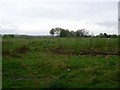
Wasteland at Auchenshuggle
This area became a famous name as it was a terminus for Glasgow's trams. The area itself is actually only waste ground and a wood, however.
Image: © Stephen Sweeney
Taken: 30 Apr 2009
0.06 miles
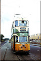
2
Glasgow tram 1176 at Auchenshuggle terminus.
Taken just before Glasgow trams were withdrawn.
Image: © Chris Coleman
Taken: Unknown
0.09 miles
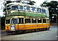
3
Glasgow tram 1293 at Auchenshuggle
Taken just before withdrawal of trams in September 1962, this shows the next tram approaching in the background, the crossover junction from the outbound line to the inbound line, and the position of the tracks in the centre of the road, set in stone paving which made for easier maintenance.
Image: © Chris Coleman
Taken: Unknown
0.10 miles
4
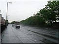
London Road
Busy dual carriageway in the East End of Glasgow. Viewed from the junction with Braidfauld Road.
Image: © Stephen Sweeney
Taken: 30 Apr 2009
0.11 miles
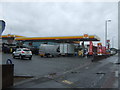
7
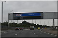
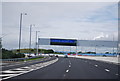
M74 construction site
Early days in the building of the M74 across southern Glasgow. This section is between the existing motorway at junction 1 and the Clyde. View from the Clyde Walkway which was still open at the time.
Image: © Richard Webb
Taken: 25 Jul 2008
0.12 miles
8
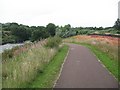
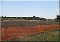
Clyde Walkway - M74 bridge site
The path here will by now have changed completely. The orange netting shows the extent of the motorway construction in July 2008. The M74 will cross the Clyde here and is due to be completed in 2011.
Image: © Richard Webb
Taken: 25 Jul 2008
0.13 miles
9
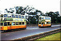
Glasgow trams at Auchenshuggle terminus
Shortly before the end of Glasgow tram services.
Image: © Chris Coleman
Taken: Unknown
0.13 miles