IMAGES TAKEN NEAR TO
Clydesmill Road, GLASGOW, G32 8RE
Introduction
This page details the photographs taken nearby to Clydesmill Road, G32 8RE by members of the Geograph project.
The Geograph project started in 2005 with the aim of publishing, organising and preserving representative images for every square kilometre of Great Britain, Ireland and the Isle of Man.

There are currently over 7.5m images from over14,400 individuals and you can help contribute to the project by visiting https://www.geograph.org.uk
Image Map
Images are licensed for reuse under creativecommons.org/licenses/by-sa/2.0
Notes
- Clicking on the map will re-center to the selected point.
- The higher the marker number, the further away the image location is from the centre of the postcode.
Image Listing (4 Images Found)
Images are licensed for reuse under creativecommons.org/licenses/by-sa/2.0
Image
Details
Distance
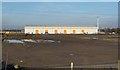
2

Cambuslang Industrial Estate
At the time, these buildings were the premises of WWW Electrical Contractors Ltd, which was subsequently (2017) wound up. The buildings later bore "VMS" branding, as the corporate offices of Visual Management Systems Ltd.
(Only the facade of the nearer of the two buildings is in the same grid square as the photographer; since both buildings are the intended subject, a point between them has been used for the subject position. Note also that although I have employed the name Cambuslang Industrial Estate because it appears on the OS map, other sources employ the names Cambuslang Investment Park and Clydesmill Industrial Estate in connection with this area.)
Image: © Lairich Rig
Taken: 3 Feb 2006
0.11 miles
3
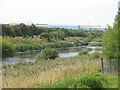
Clyde between Cambuslang and Carmyle
A mostly industrial area on both sides of the river.
Image: © Richard Webb
Taken: 25 Jul 2008
0.23 miles
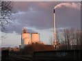
4
Cambuslang Industrial Estate
Much of the site was still undeveloped when this picture was taken; this view would now be impossible because of intervening buildings. The picture was taken from the nearby cycle path, and the stripes on the building's roof allow the viewpoint to be determined fairly accurately.
The then-undeveloped area in front of the building is shown separately from another angle in Image, taken on the same day. By 2020, when these pictures were submitted, that area had long since been occupied by additional buildings of the industrial estate.
The first-edition map (surveyed in 1858) shows a farm called Bogleshole at about Image, now roughly the northern end of the estate. The Clyde Iron Works Colliery, shown on OS maps from the second edition (1898) onwards, was near Image
The chimney on the right is not part of this building, but belongs to the more distant Image
Image: © Lairich Rig
Taken: 3 Feb 2006
0.24 miles