IMAGES TAKEN NEAR TO
Estate Road, GLASGOW, G32 8BW
Introduction
This page details the photographs taken nearby to Estate Road, G32 8BW by members of the Geograph project.
The Geograph project started in 2005 with the aim of publishing, organising and preserving representative images for every square kilometre of Great Britain, Ireland and the Isle of Man.

There are currently over 7.5m images from over14,400 individuals and you can help contribute to the project by visiting https://www.geograph.org.uk
Image Map
Images are licensed for reuse under creativecommons.org/licenses/by-sa/2.0
Notes
- Clicking on the map will re-center to the selected point.
- The higher the marker number, the further away the image location is from the centre of the postcode.
Image Listing (16 Images Found)
Images are licensed for reuse under creativecommons.org/licenses/by-sa/2.0
Image
Details
Distance
1
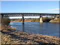
Former Carmyle Railway Viaduct
This disused viaduct formerly carried the Caledonian Railway Line from Kirkhill Junction to Carmyle across the River Clyde.
Image: © G Laird
Taken: 31 Jan 2010
0.18 miles
2
Disused railway bridge over River Clyde
Image: © Stephen Sweeney
Taken: 17 Jun 2009
0.19 miles
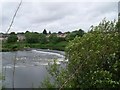
3
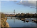
Weir and Disused Railway Bridge, River Clyde at Carmyle
Image: © Chris Upson
Taken: 3 Mar 2006
0.19 miles
4
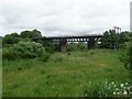
Fence around disused railway bridge
By the Clyde Walkway just north of Westburn Village.
Image: © Stephen Sweeney
Taken: 17 Jun 2009
0.20 miles
5
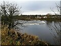
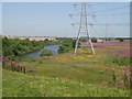
Looking across the Clyde to Carmyle
The weir and houses on the north side of the river are seen from a slightly elevated point beside the Clyde Walkway.
Image: © Alec MacKinnon
Taken: 27 Nov 2020
0.21 miles
6
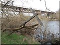
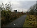
Clyde Walkway at Newton Burn
The Clyde Walkway crosses Newton Burn over two small concrete bridges; however a tree has fallen on one of the bridges, blocking it and also dislodging the wooden walkway sign. In the background is the closed railway viaduct bridge between Westburn and Carmyle
Image: © Graham Crowe
Taken: 21 Mar 2016
0.22 miles
7
Carmyle Weir
Powered the 19th century Carmyle Mill.
Image: © Stephen Sweeney
Taken: 17 Jun 2009
0.22 miles
8
Clyde Walkway approaching the disused Carmyle viaduct
Image: © Chris Wimbush
Taken: 18 Feb 2007
0.22 miles
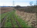
10
Clyde Walkway opposite Carmyle
The Clyde Walkway, also NCR75 at this point, passes through an area of waste ground next the River Clyde. The picture looks west, generally towards Glasgow.
Image: © Alec MacKinnon
Taken: 27 Nov 2020
0.23 miles