IMAGES TAKEN NEAR TO
Firpark Terrace, GLASGOW, G31 2JU
Introduction
This page details the photographs taken nearby to Firpark Terrace, G31 2JU by members of the Geograph project.
The Geograph project started in 2005 with the aim of publishing, organising and preserving representative images for every square kilometre of Great Britain, Ireland and the Isle of Man.

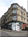
There are currently over 7.5m images from over14,400 individuals and you can help contribute to the project by visiting https://www.geograph.org.uk
Image Map
Images are licensed for reuse under creativecommons.org/licenses/by-sa/2.0
Notes
- Clicking on the map will re-center to the selected point.
- The higher the marker number, the further away the image location is from the centre of the postcode.
Image Listing (207 Images Found)
Images are licensed for reuse under creativecommons.org/licenses/by-sa/2.0
Image
Details
Distance
1
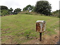
Royal Mail storage box and earth mound
Royal Mail storage box and earth mound, also the location for the Ordnance Survey Glasgow Necropolis Auxiliary bolt.
Image: © Mat Tuck
Taken: 19 Aug 2013
0.02 miles
2
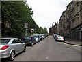
Ark Lane
The street is on two levels, with a higher road (Firpark Terrace) and set of tenements behind the trees.
Image: © Richard Webb
Taken: 16 Jun 2011
0.03 miles
3
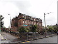
Westercraigs Nursery School
This old school building, now appears to be closed and derelict.
Image: © Mat Tuck
Taken: 19 Aug 2013
0.03 miles
4
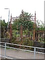
Gate, Golfhill Primary School
Ornate Boy's Gate at the now closed buildings.
Image: © Richard Webb
Taken: 16 Jun 2011
0.04 miles
5
Closed shop
Former corner shop - Park Lane, left, Broompark Drive on the right.
Image: © Richard Webb
Taken: 16 Jun 2011
0.04 miles
6
Golfhill School
Recently abandoned 1902 sandstone school building.
Image: © Richard Webb
Taken: 16 Jun 2011
0.04 miles
7
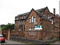
Golfhill Primary School
A now empty school building. The sandstone building was built in 1902.
Image: © Richard Webb
Taken: 16 Jun 2011
0.05 miles
8
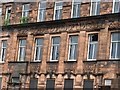
Colonised cornice
Elder and buddleia are getting established on the man made crag that is the former Golfhill Primary School.
Image: © Richard Webb
Taken: 16 Jun 2011
0.05 miles
9

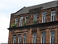
Door detail, Golfhill Primary School
The building is now empty. The sandstone school buildings of the early 1900s have some very fine stonework.
Image: © Richard Webb
Taken: 16 Jun 2011
0.05 miles
10
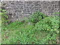
Ordnance Survey Fundamental Bench Mark
Covered in weeds, the concrete stub pillar of Glasgow Necropolis Fundamental Benchmark is shown in the image.
Image: © Mat Tuck
Taken: 19 Aug 2013
0.05 miles