IMAGES TAKEN NEAR TO
Millichen Farm Close, G23 5HP
Introduction
This page details the photographs taken nearby to Millichen Farm Close, G23 5HP by members of the Geograph project.
The Geograph project started in 2005 with the aim of publishing, organising and preserving representative images for every square kilometre of Great Britain, Ireland and the Isle of Man.

There are currently over 7.5m images from over14,400 individuals and you can help contribute to the project by visiting https://www.geograph.org.uk
Image Map
Images are licensed for reuse under creativecommons.org/licenses/by-sa/2.0
Notes
- Clicking on the map will re-center to the selected point.
- The higher the marker number, the further away the image location is from the centre of the postcode.
Image Listing (4 Images Found)
Images are licensed for reuse under creativecommons.org/licenses/by-sa/2.0
Image
Details
Distance
1
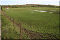
Millichen Flood
This low-lying area regularly floods and attracts good numbers of geese, ducks and other birds.
The building in the distance (in NS5771) is Summer Dell Cottage.
Image: © Richard Sutcliffe
Taken: 5 May 2006
0.15 miles
3
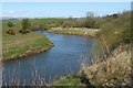
The River Kelvin
The photograph was taken from the Kelvin Walkway, in the section that passes through Balmuildy Wood.
From this part of the path, I saw many swifts darting about, catching insects over the water.
Image: © Lairich Rig
Taken: 28 Apr 2006
0.19 miles
4
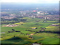
Looking towards Bishopbriggs from above Milngavie
The Antonine Wall crosses this landscape and the River Kelvin [middle foreground] marks the boundary between East Dunbartonshire and Glasgow.
Image: © M J Richardson
Taken: 20 Jun 2015
0.22 miles