IMAGES TAKEN NEAR TO
Ashgill Road, GLASGOW, G22 6QJ
Introduction
This page details the photographs taken nearby to Ashgill Road, G22 6QJ by members of the Geograph project.
The Geograph project started in 2005 with the aim of publishing, organising and preserving representative images for every square kilometre of Great Britain, Ireland and the Isle of Man.

There are currently over 7.5m images from over14,400 individuals and you can help contribute to the project by visiting https://www.geograph.org.uk
Image Map (Loading...)


Getting Data...Please wait
Leaflet Map data © OpenStreetMap
Images are licensed for reuse under creativecommons.org/licenses/by-sa/2.0
Notes
- Clicking on the map will re-center to the selected point.
- The higher the marker number, the further away the image location is from the centre of the postcode.
Image Listing (36 Images Found)
Images are licensed for reuse under creativecommons.org/licenses/by-sa/2.0
Image
Details
Distance
1
Balmore Kindergarten, Lambhill, Glasgow
A purpose-built nursery for 0 - 5 year olds, on Glentanar Road.
Image: © Christine Johnstone
Taken: 26 Jun 2019
0.06 miles
3
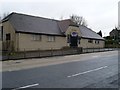
Glen Douglas, Possil Park
Derelict pub in Possil. Dereliction is sadly the theme of the area these days.
Image: © Stephen Sweeney
Taken: 20 Jan 2009
0.08 miles
4
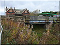
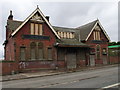
Possil Station Approach
The cutting is largely overgrown, and the bridge has been backfilled with earth. Looking eastwards to the station building, the road bridge (at the station building) has sandstone parapets, however the bridge closest to camera uses a traditional iron lattice, so whether this was initially double-width for road use then subsequently ignored, or the road was realigned after the station was built is unclear.
Possil was a terminus for all passenger services on this line - only goods trains continued under the bridge heading east to Springburn Park (Goods) Station, Stobhill, and on to the main line junction near Hogganfield Loch.
Image: © Raymond Okonski
Taken: 31 Oct 2007
0.09 miles
5
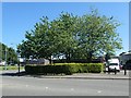
Trees in front of the Bankroll Cafe, Lambhill, Glasgow
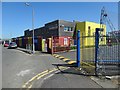
At the southern end of the Balmore industrial estate.
Image: © Christine Johnstone
Taken: 26 Jun 2019
0.09 miles
6
![Balmore Road [A879], Lambhill, Glasgow](https://s3.geograph.org.uk/geophotos/06/20/58/6205887_4f881166_120x120.jpg)
Balmore Road [A879], Lambhill, Glasgow
Heading north.
Image: © Christine Johnstone
Taken: 26 Jun 2019
0.09 miles
8
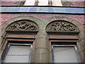
Possil Station
This impressive station building belonged to the Caledonian Railway (the carvings still visible above the arched windows feature the ornate letters 'C', 'R' and the corporate logo). Possil station was on the Caledonian's Hamiltonhill Branch, connecting Maryhill to Robroyston.
Image: © Raymond Okonski
Taken: 31 Oct 2007
0.11 miles
10
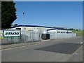
PARS Foods, Glentanar Road, Glasgow
Producers of pies and pastries since 1952.
Image: © Christine Johnstone
Taken: 26 Jun 2019
0.11 miles