IMAGES TAKEN NEAR TO
Kippen Gate, GLASGOW, G22 6FA
Introduction
This page details the photographs taken nearby to Kippen Gate, G22 6FA by members of the Geograph project.
The Geograph project started in 2005 with the aim of publishing, organising and preserving representative images for every square kilometre of Great Britain, Ireland and the Isle of Man.

There are currently over 7.5m images from over14,400 individuals and you can help contribute to the project by visiting https://www.geograph.org.uk
Image Map
Images are licensed for reuse under creativecommons.org/licenses/by-sa/2.0
Notes
- Clicking on the map will re-center to the selected point.
- The higher the marker number, the further away the image location is from the centre of the postcode.
Image Listing (44 Images Found)
Images are licensed for reuse under creativecommons.org/licenses/by-sa/2.0
Image
Details
Distance
1

Chirnsyde Primary School
On Ashgill Road. An early post-World War II primary school. It is Category B listed http://portal.historicenvironment.scot/designation/LB33735.
Image: © Richard Sutcliffe
Taken: 19 Jan 2023
0.10 miles
2
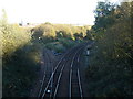
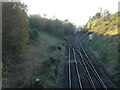
Ashfield Junction
Looking east, the single track spur is not used for passenger traffic, but allows trains from Maryhill to connect with the northbound lines to Bishopbriggs and beyond. The main route connects to Cowlairs North Junction and south to either Springburn or Queen Street stations.
Image: © Raymond Okonski
Taken: 19 Oct 2007
0.12 miles
3
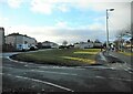
Amenity grassland
An oblong of amenity grassland between Ashgill Road (on the right) and Harmetray Street (on the left)
Image: © Richard Sutcliffe
Taken: 19 Jan 2023
0.13 miles
4
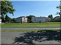
Houses on Eday and Harmetray Streets, Glasgow
Developed since World War Two.
Image: © Christine Johnstone
Taken: 26 Jun 2019
0.13 miles
5
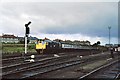
Eastfield 1978 - Edinburgh-Glasgow push-pull train passing council houses
One of the 1970s push-pull trains using a class 27 locomotive at both ends of the coaching stock passes Eastfield depot on the final approach to Glasgow Queen St station. Taken in Nov or Dec 1978. Typical council houses behind the train.
Image: © Peter Whatley
Taken: Unknown
0.14 miles
6
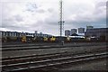
Rolling stock at Springburn, with Red Road Flats in the background
Image: © Elliott Simpson
Taken: Unknown
0.14 miles
7
Ashfield Approach
A diesel commuter train calls at Ashfield station on a reopened section of track providing passenger services to Maryhill and Anniesland. The crossover provides a connection to the northbound main line to Bishopbriggs and beyond.
Image: © Raymond Okonski
Taken: 19 Oct 2007
0.14 miles
8
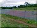
All weather pitch in, Chirnsyde Primary School
Image: © Alex McGregor
Taken: 7 Jun 2011
0.15 miles
9
Eastfield depot and surrounding council flats 1978
The old Eastfield diesel depot in late 1978 (Nov/Dec) with a variety of locomotives on shed.
Image: © Peter Whatley
Taken: Unknown
0.15 miles
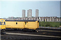
10
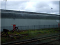
Shed and buffers
At Eastfield Depot. Click on this http://www.kirwindesign.co.uk/Eastfield_real.htm for more information about the depot.
Image: © Thomas Nugent
Taken: 11 Jul 2010
0.15 miles