IMAGES TAKEN NEAR TO
Chestnut Street, GLASGOW, G22 6ET
Introduction
This page details the photographs taken nearby to Chestnut Street, G22 6ET by members of the Geograph project.
The Geograph project started in 2005 with the aim of publishing, organising and preserving representative images for every square kilometre of Great Britain, Ireland and the Isle of Man.

There are currently over 7.5m images from over14,400 individuals and you can help contribute to the project by visiting https://www.geograph.org.uk
Image Map
Images are licensed for reuse under creativecommons.org/licenses/by-sa/2.0
Notes
- Clicking on the map will re-center to the selected point.
- The higher the marker number, the further away the image location is from the centre of the postcode.
Image Listing (39 Images Found)
Images are licensed for reuse under creativecommons.org/licenses/by-sa/2.0
Image
Details
Distance
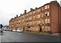
2
Spruce Street
The photograph was taken from the point where this street leaves the main road (Hawthorn Street), and is a view towards the point where it meets Walnut Road.
The prominent building on the right is the clubhouse of Hawthorn Bowling Club; the bowling green itself is behind the hedge.
Image: © Lairich Rig
Taken: 11 Oct 2010
0.09 miles
3
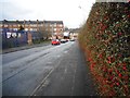
Carlisle Street
A good crop of berries are still on the hedge, despite it being the beginning of March.
Image: © Richard Sutcliffe
Taken: 2 Mar 2017
0.10 miles
4
Ashfield Approach
A diesel commuter train calls at Ashfield station on a reopened section of track providing passenger services to Maryhill and Anniesland. The crossover provides a connection to the northbound main line to Bishopbriggs and beyond.
Image: © Raymond Okonski
Taken: 19 Oct 2007
0.11 miles
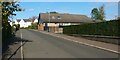
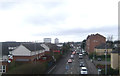
5

Houses on Walnut Road
Viewed from across Hawthorn Street (B808). Walnut Street once joined onto the main road, but is now separated by a series of bollards.
Image: © Richard Sutcliffe
Taken: 2 Mar 2017
0.11 miles
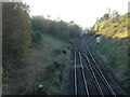
6
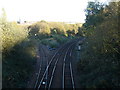
Ashfield Junction
Looking east, the single track spur is not used for passenger traffic, but allows trains from Maryhill to connect with the northbound lines to Bishopbriggs and beyond. The main route connects to Cowlairs North Junction and south to either Springburn or Queen Street stations.
Image: © Raymond Okonski
Taken: 19 Oct 2007
0.11 miles
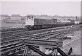
7
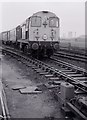
Class 20 at Cowlairs
Unidentified British Rail Class 20 locomotive with train at Cowlairs.
Image: © Richard Sutcliffe
Taken: Unknown
0.13 miles
9
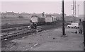
Type 2s at Cowlairs
Two unidentified Sulzer Type 2 locomotives at Cowlairs. Railway workmen undertaking some kind of track maintenance.
Image: © Richard Sutcliffe
Taken: Unknown
0.14 miles
10
Class 25 at Cowlairs
British Rail Class 25/2 No 7580 with a freight train at Cowlairs.
Image: © Richard Sutcliffe
Taken: Unknown
0.14 miles