IMAGES TAKEN NEAR TO
Auckland Street, GLASGOW, G22 5NY
Introduction
This page details the photographs taken nearby to Auckland Street, G22 5NY by members of the Geograph project.
The Geograph project started in 2005 with the aim of publishing, organising and preserving representative images for every square kilometre of Great Britain, Ireland and the Isle of Man.

There are currently over 7.5m images from over14,400 individuals and you can help contribute to the project by visiting https://www.geograph.org.uk
Image Map
Images are licensed for reuse under creativecommons.org/licenses/by-sa/2.0
Notes
- Clicking on the map will re-center to the selected point.
- The higher the marker number, the further away the image location is from the centre of the postcode.
Image Listing (103 Images Found)
Images are licensed for reuse under creativecommons.org/licenses/by-sa/2.0
Image
Details
Distance
1
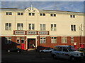
Partick Thistle Football Ground
aka Firhill Park, home of the Jags
Image: © Chris Upson
Taken: 6 Sep 2005
0.04 miles
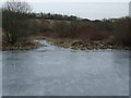
2
Arm off the Forth and Clyde Canal Glasgow Branch
Old maps show that this served a claypit where the ground rises at the back, and also the Hamiltonhill Slip, a boatbuilding yard just on the right hand side of the entrance to the arm.
Image: © Alan Murray-Rust
Taken: 25 Jun 2019
0.17 miles
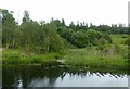
3
Forth and Clyde Canal
The entrance to an overgrown old dock or basin near Firhill.
Image: © Thomas Nugent
Taken: 13 Feb 2009
0.18 miles

5
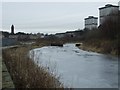
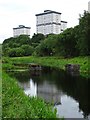
Forth and Clyde Canal
Looking towards Firhill basin from the east. The tower to the left is at the derelict Ruchill Hospital Image
Image: © Thomas Nugent
Taken: 13 Feb 2009
0.18 miles
6
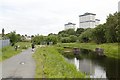
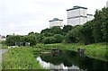
Wester Common Road flats
Wester Common Road flats reflected in the Forth and Clyde Canal.
Image: © Philip Halling
Taken: 25 Jun 2019
0.18 miles
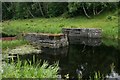
7
Safety Gate, Firhill Basin
This gate was installed during World War 2. If the canal was bombed, the gates could be closed to prevent flooding.
Image: © Mark Anderson
Taken: 25 Jun 2019
0.19 miles
8
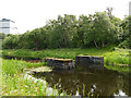
Stone piers in the canal near Firhill Basin
I had taken these to be old bridge piers, but the 1950 OS map calls them "safety gates", allowing the gap between them to be filled quickly in the event of the canal being breached, see also Image
Image: © Stephen Craven
Taken: 25 Jun 2019
0.19 miles
9
Stop lock
Built during World War II, this is one of three similar structures which were constructed to allow sections of the Glasgow Branch of the Forth and Clyde Canal to be shut off in the event of bomb damage to the canal.
Image: © Richard Sutcliffe
Taken: 25 Jun 2019
0.19 miles
10
Stop lock
Built during World War II, this was one of three similar structures which were constructed to allow sections of the Glasgow Branch of the Forth and Clyde Canal to be shut off in the event of bomb damage to the canal.
Image: © Richard Sutcliffe
Taken: 25 Jun 2019
0.19 miles