IMAGES TAKEN NEAR TO
Monar Place, GLASGOW, G22 5EH
Introduction
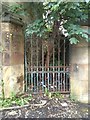
This page details the photographs taken nearby to Monar Place, G22 5EH by members of the Geograph project.
The Geograph project started in 2005 with the aim of publishing, organising and preserving representative images for every square kilometre of Great Britain, Ireland and the Isle of Man.

There are currently over 7.5m images from over14,400 individuals and you can help contribute to the project by visiting https://www.geograph.org.uk
Image Map
Images are licensed for reuse under creativecommons.org/licenses/by-sa/2.0
Notes
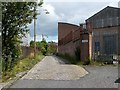
- Clicking on the map will re-center to the selected point.
- The higher the marker number, the further away the image location is from the centre of the postcode.
Image Listing (102 Images Found)
Images are licensed for reuse under creativecommons.org/licenses/by-sa/2.0
Image
Details
Distance
1
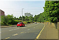
Possil Road
Looking down the hill towards the canal.
Image: © Mary and Angus Hogg
Taken: 31 Jul 2024
0.05 miles
2
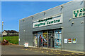
The Glasgow Angling Centre
Also the home of Glasgow Field Sports. That’s a conveniently located seat outside for anyone waiting for a customer to come out.
Image: © Mary and Angus Hogg
Taken: 31 Jul 2024
0.06 miles
3
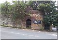
All that remains of Rockvilla School
The school building and janitor's house were demolished in 1996. Today all that remains of the school is its curved retaining wall, with the separate entrance steps for boys and girls, which are Category B listed http://portal.historicenvironment.scot/designation/LB33621. These separate entrances are an original feature of the school. They were a specific requirement of the Glasgow School Board which, although allowing co-educational schools, rigidly enforced the rule that boys and girls must be kept apart as much as possible. See Canmore https://canmore.org.uk/site/161877/glasgow-184-possil-road-rockvilla-school-and-retaining-wall for more information.
Image: © Richard Sutcliffe
Taken: 24 Jul 2020
0.10 miles
4
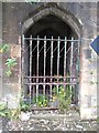
Boys' entrance, former Rockvilla School
The school building and janitor's house were demolished in 1996. Today all that remains of the school is its curved retaining wall, with the separate entrance steps for boys and girls, which are Category B listed http://portal.historicenvironment.scot/designation/LB33621. These separate entrances are an original feature of the school. They were a specific requirement of the Glasgow School Board which, although allowing co-educational schools, rigidly enforced the rule that boys and girls must be kept apart as much as possible. See Canmore https://canmore.org.uk/site/161877/glasgow-184-possil-road-rockvilla-school-and-retaining-wall for more information.
Image: © Richard Sutcliffe
Taken: 24 Jul 2020
0.10 miles
5
Girls' entrance, former Rockvilla School
The school building and janitor's house were demolished in 1996. Today all that remains of the school is its curved retaining wall, with the separate entrance steps for boys and girls, which are Category B listed http://portal.historicenvironment.scot/designation/LB33621. These separate entrances are an original feature of the school. They were a specific requirement of the Glasgow School Board which, although allowing co-educational schools, rigidly enforced the rule that boys and girls must be kept apart as much as possible. See Canmore https://canmore.org.uk/site/161877/glasgow-184-possil-road-rockvilla-school-and-retaining-wall for more information.
Image: © Richard Sutcliffe
Taken: 24 Jul 2020
0.10 miles
6
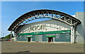
The Point
A business park for trade and retail services.
Image: © Mary and Angus Hogg
Taken: 31 Jul 2024
0.10 miles
7
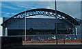
The Point Business Retail Park
Possilpark Glasgow.
Image: © wfmillar
Taken: 23 Mar 2015
0.10 miles
8
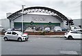
The Point
The Point is a trade and retail Park at the corner of Saracen Street and Possil Road.
Image: © Richard Sutcliffe
Taken: 24 Jul 2020
0.10 miles
9
Dawson Road
The road leads from Possil Road to Craighall Road / Saracen Street.
Image: © Lairich Rig
Taken: 19 Jul 2011
0.10 miles
10
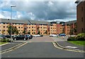
Housing development at Possil Road / Craighall Road
When this picture was taken, the buildings had been there for only a few years (work was completed here about mid-2005); there are about 130 individual homes. The area is bounded on three sides by Possil Road, Craighall Road, and Dawson Road.
The cobbled lane shown in Image leads here; in fact, some of the buildings in this development can be seen indistinctly in that picture, behind trees at the far end of the lane.
Image: © Lairich Rig
Taken: 19 Jul 2011
0.10 miles