IMAGES TAKEN NEAR TO
Avonspark Place, GLASGOW, G21 4PE
Introduction
This page details the photographs taken nearby to Avonspark Place, G21 4PE by members of the Geograph project.
The Geograph project started in 2005 with the aim of publishing, organising and preserving representative images for every square kilometre of Great Britain, Ireland and the Isle of Man.

There are currently over 7.5m images from over14,400 individuals and you can help contribute to the project by visiting https://www.geograph.org.uk
Image Map
Images are licensed for reuse under creativecommons.org/licenses/by-sa/2.0
Notes
- Clicking on the map will re-center to the selected point.
- The higher the marker number, the further away the image location is from the centre of the postcode.
Image Listing (10 Images Found)
Images are licensed for reuse under creativecommons.org/licenses/by-sa/2.0
Image
Details
Distance
1

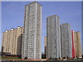
Petershill Road looking towards Red Road Tower Blocks
Image: © Chris Upson
Taken: 10 Feb 2006
0.14 miles
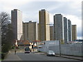
2
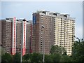
Red Road flats at Balornock
The Red Road development was approved in 1962, and comprises six, 31-storeyed tower blocks containing 720 flats, two 27-storeyed slab blocks and one three-storeyed block. They were designed by Sam Bunton & Associates for Glasgow Corporation.
Image: © Chris Upson
Taken: 10 Feb 2006
0.15 miles
3
Red Road Flats, Balornock (from Petershill Road)
The original Red Road after which the tower blocks were named was a dirt track bounded by the former Low Balornock Farm and Barmulloch Farm. These 8 tower blocks were built 1962-1969 on this area. At 31 storeys they were then the tallest tower blocks in Europe. The current site is bounded by Petershill Drive and the modern Red Road. The flats were designed by architect Sam Brunton and built to replace slum tenements, but residents were complaining about the poor conditions by 1971. The most distant tower block (also the one in the photograph farthest to the right) is now due for demolition.
Image: © G Laird
Taken: 28 Mar 2009
0.18 miles
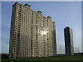
4
Red Road Tower Blocks, Balornock
31-storey tower blocks, once the highest in Europe
Image: © Chris Upson
Taken: 10 Feb 2006
0.18 miles
5
Red Road Tower Blocks, Glinting in the Sun
Image: © Chris Upson
Taken: 10 Feb 2006
0.18 miles
6
Red Road flats seen from Blairskaith Muir
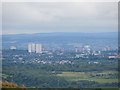
View south from the triangulation pillar (NS 59566 76746) towards Glasgow with the surviving flats visible. This view will change as more of the high rise buildings are demolished.
Image: © Richard Webb
Taken: 31 May 2013
0.19 miles
7
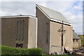
Tron St Mary's Church of Scotland, Red Road, Glasgow
Image: © Leslie Barrie
Taken: 29 Apr 2014
0.21 miles
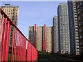
8
Red Road flats, Glasgow
Covered in red netting in preparation for demolition. Viewed from the M8 motorway near Provan Gas Works.
Image: © Thomas Nugent
Taken: 7 Aug 2014
0.21 miles
9
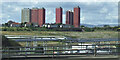
Red Road flats
The famous collection of tower blocks on the Red Road are to be demolished. The nearer block here is now in the hands of Safedem who hopefully will provide a spectacle in a few months' time.
Image: © Richard Webb
Taken: 16 Jun 2011
0.23 miles
10
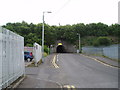
Road Tunnel
Very low but long tunnel (about 80m) controlled by Traffic lights on Darnick Street Glasgow. The overgrown embankment hides an active train line. 28th July 2009 3.45p.m.
Image: © Gordon Dowie
Taken: 28 Jul 2009
0.23 miles