IMAGES TAKEN NEAR TO
Edgefauld Road, GLASGOW, G21 4NB
Introduction
This page details the photographs taken nearby to Edgefauld Road, G21 4NB by members of the Geograph project.
The Geograph project started in 2005 with the aim of publishing, organising and preserving representative images for every square kilometre of Great Britain, Ireland and the Isle of Man.

There are currently over 7.5m images from over14,400 individuals and you can help contribute to the project by visiting https://www.geograph.org.uk
Image Map
Images are licensed for reuse under creativecommons.org/licenses/by-sa/2.0
Notes
- Clicking on the map will re-center to the selected point.
- The higher the marker number, the further away the image location is from the centre of the postcode.
Image Listing (39 Images Found)
Images are licensed for reuse under creativecommons.org/licenses/by-sa/2.0
Image
Details
Distance
1
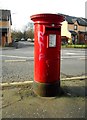
Pillar box on Edgefauld Road
Postbox number G21 214D.
Image: © Richard Sutcliffe
Taken: 2 Mar 2017
0.01 miles
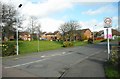
2
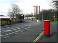
Edgefauld Road
Looking past the pedestrian only entrance to Barnhill railway station on the left towards the tall Newlands and Wellfield flats in the distance. The pillar box in the foreground is postbox number G21 214D [http://www.geograph.org.uk/photo/5300352].
Image: © Richard Sutcliffe
Taken: 2 Mar 2017
0.02 miles
3
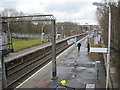
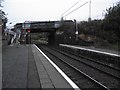
Barnhill railway station, Glasgow
Opened in 1883 by the City of Glasgow Union Railway on the line from Bellgrove to Springburn. View north west towards Springburn.
Image: © Nigel Thompson
Taken: 15 Mar 2013
0.04 miles
4
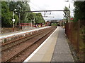
Barnhill railway station
On the line between Bellgrove and Springburn.
Image: © Thomas Nugent
Taken: 1 Dec 2012
0.05 miles
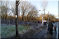
5
Petershill Road crosses the railway and provides access to Barnhill station
Image: © Tim Glover
Taken: 22 Sep 2014
0.05 miles
6
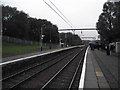
Barnhill Rail Station Glasgow
Unmanned rail station off Petershill Road Glasgow 28th July 2009 3.55p.m.
Image: © Gordon Dowie
Taken: 28 Jul 2009
0.05 miles
8
Barnhill railway station
Looking down from Petershill Road.
Image: © Richard Sutcliffe
Taken: 2 Mar 2017
0.07 miles
9
Houses on Foresthall Drive
Seen from the junction with Edgefauld Road.
Image: © Richard Sutcliffe
Taken: 2 Mar 2017
0.08 miles
10
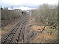
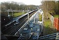
Stepps-Springburn railway line, Barnhill
The line from Cumbernauld and Stepps used to run into Glasgow Buchanan Street station. Since that closed in 1966, trains now run in an inverted 'S' shape past Barnhill railway station (out of view immediately to the right of this image) and then left into Glasgow Queen Street (High Level).
Image: © Nigel Thompson
Taken: 15 Mar 2013
0.08 miles