IMAGES TAKEN NEAR TO
Royston Road, GLASGOW, G21 2BS
Introduction
This page details the photographs taken nearby to Royston Road, G21 2BS by members of the Geograph project.
The Geograph project started in 2005 with the aim of publishing, organising and preserving representative images for every square kilometre of Great Britain, Ireland and the Isle of Man.

There are currently over 7.5m images from over14,400 individuals and you can help contribute to the project by visiting https://www.geograph.org.uk
Image Map
Images are licensed for reuse under creativecommons.org/licenses/by-sa/2.0
Notes
- Clicking on the map will re-center to the selected point.
- The higher the marker number, the further away the image location is from the centre of the postcode.
Image Listing (35 Images Found)
Images are licensed for reuse under creativecommons.org/licenses/by-sa/2.0
Image
Details
Distance
1
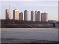
Frozen Football Pitch, Royston
Overshadowed by the Red Road Tower Blocks
Image: © Chris Upson
Taken: 18 Feb 2006
0.03 miles
2
St Roch's Catholic Church
St Roch’s Church and Primary School across the road https://www.geograph.org.uk/photo/6249060 were built in 1907.
According to the church's website, 'St Roch was born around 1295 in Montpellier, southern France. Like St Francis of Assisi, he gave away all his possessions to become a pilgrim for Christ. On his way to Rome he gave himself to the care of the sick and the victims of the plague, but eventually he himself contracted the plague (signified on his statue by the wound on his leg.) He retreated to a forest and a dog belonging to a St Gothard would come to him bringing food from its master’s table. He survived the disease. On returning to Montpellier he was not recognised, suspected of being a spy, thrown into prison and died at the age of 32. Only after his death was he recognised. Devotion spread rapidly. Today there are festivals established in many towns and villages in Northern Spain, France and Italy during the week of 16th August, his feast day.'
Image: © Richard Sutcliffe
Taken: 23 Aug 2019
0.03 miles
3
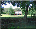
Glenconner park bowling greens and pavilion
On Royston Road. Long disused and boarded-up, survives the attention of developers due to a condition of the original gifting of the park to the city by Lord Glenconner in 1915.
See also Image
Image: © Thomas Nugent
Taken: 24 Aug 2022
0.05 miles
4
Glenconner Park bowling greens and pavilion
On Royston Road. Long disused and boarded-up, survives the attention of developers due to a condition of the original gifting of the park to the city by Lord Glenconner in 1915.
See also Image
Image: © Thomas Nugent
Taken: 24 Aug 2022
0.05 miles
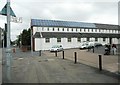
5
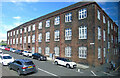
St Roch's RC Primary School
On Royston Road at Brodick Street, which is where the cars are parked.
Image: © Thomas Nugent
Taken: 24 Aug 2022
0.05 miles
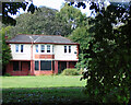
6
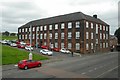
St Roch's Primary School
A substantial building at the junction of Royston Road and Brodick Street. It, together with St Roch’s Church across the road were built in 1907.
Image: © Richard Sutcliffe
Taken: 23 Aug 2019
0.05 miles
7
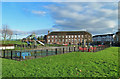
Glenconner Park
Children's play area on Royston Road.
Image: © Mary and Angus Hogg
Taken: 22 Nov 2014
0.08 miles
8
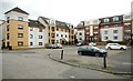
Flats on Royston Road
These flats are set back from the main road.
Image: © Richard Sutcliffe
Taken: 23 Aug 2019
0.10 miles
9
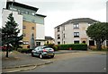
Properties at Cloverbank Gardens
Built by the Blochairn Housing Association in 1995. A large plaque above the entrance to the block on the right reads:
1 9
BHA
9 5
For a closer view of Andy Scott's sculpture on the left, see https://www.geograph.org.uk/photo/6249122.
Image: © Richard Sutcliffe
Taken: 23 Aug 2019
0.12 miles
10
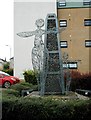
Sculpture, Cloverbank Gardens
Created for Blochairn Housing Association in 2002 by sculptor Andy Scott, better known for 'The Kelpies'. The stone cairn represents Blochairn, which means 'place of stones' and the people figures have open arms welcoming you to the Blochairn community.
Image: © Richard Sutcliffe
Taken: 23 Aug 2019
0.13 miles