IMAGES TAKEN NEAR TO
Leeside Road, GLASGOW, G21 1XN
Introduction
This page details the photographs taken nearby to Leeside Road, G21 1XN by members of the Geograph project.
The Geograph project started in 2005 with the aim of publishing, organising and preserving representative images for every square kilometre of Great Britain, Ireland and the Isle of Man.

There are currently over 7.5m images from over14,400 individuals and you can help contribute to the project by visiting https://www.geograph.org.uk
Image Map
Images are licensed for reuse under creativecommons.org/licenses/by-sa/2.0
Notes
- Clicking on the map will re-center to the selected point.
- The higher the marker number, the further away the image location is from the centre of the postcode.
Image Listing (20 Images Found)
Images are licensed for reuse under creativecommons.org/licenses/by-sa/2.0
Image
Details
Distance
1
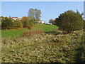
Lanarkshire and Dunbartonshire Railway Trackbed
This rough terrain is the route (on an embankment) of the old Lanarkshire and Dunbartonshire Railway, which linked Maryhill Central to Springburn Park goods station (Located adjacent to Farmfoods close to Balgrayhill Rd)). No formal path exists, but it is possible to follow the route all the way to Stobhill Hospital.
Image: © Raymond Okonski
Taken: 23 Oct 2007
0.12 miles
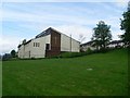
2

Farmfoods
Frozen food store just off Springburn Road.
Image: © Stephen Sweeney
Taken: 27 May 2009
0.15 miles
3
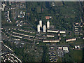
Springburn from the air
The Balgrayhill towerblocks and Springburn Park are prominent, as is Stobhill Hospital which is to the top left.
Image: © Thomas Nugent
Taken: 1 May 2017
0.17 miles
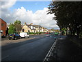
4
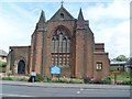
Church of Scotland church on Springburn Road
Image: © Stephen Sweeney
Taken: 27 May 2009
0.17 miles
5
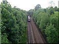
Railway line in Bishopbriggs
Train heading to Glasgow Queen Street, probably coming in from Edinburgh.
Image: © Stephen Sweeney
Taken: 27 May 2009
0.17 miles
6
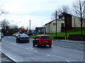
Springburn Road
Viewed from just outside the KFC drive-thru.
Image: © Thomas Nugent
Taken: 5 Feb 2012
0.17 miles
7

Glasgow, Eastfield: westbound freight on Balornock Junction - Maryhill line, 1961
View eastward on the ex-Caledonian Railway, Lanarkshire & Dumbartonshire section (subsequently closed), on the viaduct crossing the ex-NBR main line from Glasgow Queen Street and the exit from Eastfield Locomotive Depot. The westbound Class J freight is hauled by ex-CR McIntosh '812' class 3F 0-6-0 No. 57592 (built 1900, withdrawn 8/63).
Image: © Ben Brooksbank
Taken: 5 Oct 1961
0.18 miles
8
Springfield Baptist Church
In the north, near Bishopbriggs Cross.
Image: © Stephen Sweeney
Taken: 27 May 2009
0.19 miles
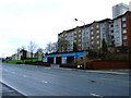
9
Crossroads at the end of Springburn Road (A803)
Springburn Road continues as Kirkintilloch Road, still the A803, on the other side of the crossroads. Colston Road (B812) crosses at this point.
Image: © G Laird
Taken: 30 Oct 2010
0.22 miles
10
Springburn Road
Viewed from just outside the KFC drive-thru.
Image: © Thomas Nugent
Taken: 5 Feb 2012
0.22 miles