IMAGES TAKEN NEAR TO
Huntingdon Road, GLASGOW, G21 1RS
Introduction
This page details the photographs taken nearby to Huntingdon Road, G21 1RS by members of the Geograph project.
The Geograph project started in 2005 with the aim of publishing, organising and preserving representative images for every square kilometre of Great Britain, Ireland and the Isle of Man.

There are currently over 7.5m images from over14,400 individuals and you can help contribute to the project by visiting https://www.geograph.org.uk
Image Map
Images are licensed for reuse under creativecommons.org/licenses/by-sa/2.0
Notes
- Clicking on the map will re-center to the selected point.
- The higher the marker number, the further away the image location is from the centre of the postcode.
Image Listing (59 Images Found)
Images are licensed for reuse under creativecommons.org/licenses/by-sa/2.0
Image
Details
Distance
1
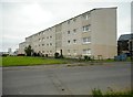
The rear of flats on Huntingdon Road
Image: © Richard Sutcliffe
Taken: 24 Jul 2020
0.00 miles
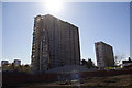
2
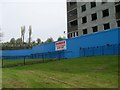
Demolition site in Sighthill
One of the flats is coming down.
Image: © Stephen Sweeney
Taken: 20 Apr 2009
0.02 miles
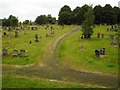
3
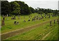
Sighthill Cemetery
Looking from Fountainwell Road.
Image: © Richard Sutcliffe
Taken: 24 Jul 2020
0.05 miles
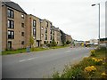
4
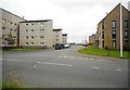
Huntingdon Road
New housing in Sighthill.
Image: © Richard Sutcliffe
Taken: 24 Jul 2020
0.05 miles
5
Sighthill Cemetery
Looking from Fountainwell Road.
Image: © Richard Sutcliffe
Taken: 24 Jul 2020
0.07 miles
6
Fountainwell Road
New housing in Sighthill. St Rollox Church can be seen just behind the lamp post.
Image: © Richard Sutcliffe
Taken: 24 Jul 2020
0.07 miles
7
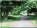
Path, Sighthill
Path through parkland by high rise housing. It is signposted as a cycle path to Cumbernauld.
Image: © Richard Webb
Taken: 16 Jun 2011
0.08 miles
8
Sighthill high rise demolition & contamination
There’s a terrible smell all over Glasgow’s Sighthill Park and while one worker drilled into the ground he told me the land is contaminated as black stinking sludge came out of the ground.
It looks like burst sewage pipes are to blame for the gigantic mess judging by all the scarring of the land. While in the background demolition teams set about removing one of the last two high rise tower blocks along the main road.
You’ll find other images here : https://www.flickr.com/photos/its-all-pretty-cool_dot-com/albums/72157667353959801
Image: © david cameron photographer
Taken: 21 Apr 2016
0.09 miles
9
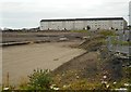
Development site, Sighthill
A large area of ground has been cleared in readiness for rebuilding here, as part of the Sighthill Regeneration Project, being undertaken by Glasgow City Council. This will mainly be housing. The area in the foreground was previously the site of the St Rollox Church of Scotland. This has been replaced by a newly built church a few hundred metres to the northwest Image
Image: © Richard Sutcliffe
Taken: 24 Jul 2020
0.09 miles
10
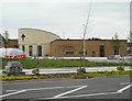
St Rollox Church
This new Church of Scotland was officially opened on Sunday 6th October 2019. It has been built as part of the masterplan for the Sighthill Regeneration Project, being undertaken by Glasgow City Council. Sculptor Michael Visocchi is creating a series of crosses in different styles to be placed on the exterior wall of the church.
Image: © Richard Sutcliffe
Taken: 24 Jul 2020
0.12 miles