IMAGES TAKEN NEAR TO
Leyden Court, GLASGOW, G20 9LY
Introduction
This page details the photographs taken nearby to Leyden Court, G20 9LY by members of the Geograph project.
The Geograph project started in 2005 with the aim of publishing, organising and preserving representative images for every square kilometre of Great Britain, Ireland and the Isle of Man.

There are currently over 7.5m images from over14,400 individuals and you can help contribute to the project by visiting https://www.geograph.org.uk
Image Map
Images are licensed for reuse under creativecommons.org/licenses/by-sa/2.0
Notes
- Clicking on the map will re-center to the selected point.
- The higher the marker number, the further away the image location is from the centre of the postcode.
Image Listing (100 Images Found)
Images are licensed for reuse under creativecommons.org/licenses/by-sa/2.0
Image
Details
Distance
1
![Glasgow buildings [10]](https://s1.geograph.org.uk/geophotos/06/24/84/6248405_3930fe1a_120x120.jpg)
Glasgow buildings [10]
Seen across the canal are these ugly modern houses.
Image: © Michael Dibb
Taken: 25 Jun 2019
0.03 miles
2
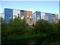
Mondriaan complex buildings
The design of these modern residential blocks (viewed here from the Forth and Clyde Canal towpath) is apparently influenced by the Dutch artist the complex is named after. Is this a landmark exercise in gentrification or a future ghetto?
Image: © Mark Nightingale
Taken: 30 Sep 2009
0.05 miles
3
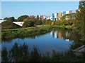
The Mondriaan development
This is a view over a branch of the Forth and Clyde Canal, looking towards the buildings of Shuna Crescent. These are part of a colourful new housing development whose look is inspired by the later works of Dutch artist Piet Mondrian (see Image).
When this photograph was taken, construction was still taking place elsewhere on the site.
- - • - -
As noted at Image, this new development is on land that had formerly been occupied by industrial buildings. Early OS maps show that, at the end of the nineteenth century, the area of this housing development was the location of (from west to east) a chemical works, a rubber works, a gold extracting works, and Caledonia Foundry.
The "chemical works" was Glasgow Lead and Colour Works; see https://canmore.org.uk/site/259600/glasgow-50-56-ruchill-street-glasgow-lead-and-colour-works (at Canmore) for images.
The "rubber works" was Glasgow Rubber Works, established by George McLellan and Co., and shown on later OS maps as "Glasgow Rubber and Asbestos Works". See https://canmore.org.uk/site/127638/glasgow-125-129-shuna-street-glasgow-rubber-works (at Canmore) for images and for further details.
The "gold extracting works" was operated by the Cassel Gold Extracting Company, and used the MacArthur-Forrest process, or "cyanide process"; the use of this process to extract gold from low-quality ore was then new. The company had acquired patent rights to this process, but these would prove to be the subject of much litigation. An OS map from 1913 shows that the works had expanded to the north-east; on that map, the site is labelled "Cassel Cyanide Works".
The last of the above-mentioned works was Caledonia Foundry; this was operated by Kerr and Co., Ltd. See https://canmore.org.uk/site/174589/glasgow-35-9-shuna-street-caledonia-foundry (at Canmore) for images of the foundry building. The company had earlier been based at Firhill.
Image: © Lairich Rig
Taken: 11 Oct 2010
0.05 miles
4
Maryhill Road, Glasgow
At the corner of Sandfield Street
Image: © Leslie Barrie
Taken: 29 Apr 2014
0.06 miles
5
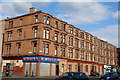
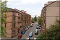
Leyden Street, Maryhill
Tenement housing seen from the Bilsland Drive aqueduct on the Glasgow branch of the Forth and Clyde Canal.
Image: © Stephen McKay
Taken: 25 Jun 2019
0.06 miles
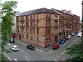
6
Tenements on Leyden Street
Viewed from the canal bridge.
Image: © Mark Anderson
Taken: 25 Jun 2019
0.07 miles
7
Bilsland Drive Aqueduct, Forth and Clyde Canal
Built in 1879 at the instigation of the City of Glasgow when the city was expanding, over what was then a new road.
Image: © Alan Murray-Rust
Taken: 25 Jun 2019
0.07 miles
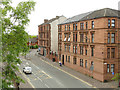
8
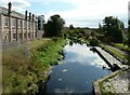
Buildings on Bilsland Drive
Buildings on the junction of Bilsland Drive and Leyden Street viewed from the towpath of the Forth and Clyde Canal.
Image: © Philip Halling
Taken: 25 Jun 2019
0.07 miles
9
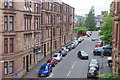
Bilsland Drive, Glasgow
Seen from the elevated canal towpath.
Image: © Stephen Craven
Taken: 25 Jun 2019
0.08 miles
10
Forth and Clyde Canal at Ruchil Wharf
Seen from the Ruchill Street bridge. The building on the left was built for Glasgow Lead and Colour Works (Alexander Ferguson and Company) about 1874. It is Category C listed http://portal.historicenvironment.scot/designation/LB33752.
Image: © Richard Sutcliffe
Taken: 13 Sep 2021
0.09 miles