IMAGES TAKEN NEAR TO
Craigmont Drive, GLASGOW, G20 9BS
Introduction
This page details the photographs taken nearby to Craigmont Drive, G20 9BS by members of the Geograph project.
The Geograph project started in 2005 with the aim of publishing, organising and preserving representative images for every square kilometre of Great Britain, Ireland and the Isle of Man.

There are currently over 7.5m images from over14,400 individuals and you can help contribute to the project by visiting https://www.geograph.org.uk
Image Map
Images are licensed for reuse under creativecommons.org/licenses/by-sa/2.0
Notes
- Clicking on the map will re-center to the selected point.
- The higher the marker number, the further away the image location is from the centre of the postcode.
Image Listing (91 Images Found)
Images are licensed for reuse under creativecommons.org/licenses/by-sa/2.0
Image
Details
Distance
1
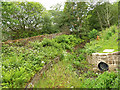
Canal overflow channel
The channel, unsurprisingly dry in what was a hot summer week, outfalls to the Possil Burn.
Image: © Stephen Craven
Taken: 25 Jun 2019
0.03 miles
2
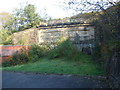
Hidden Depths
Located directly behind a bingo hall in Maryhill is this rather imposing sandstone structure. Its reason for being there isn't apparent unless you check out the OS Map. This was part of the Glasgow Central Railway, that ran from Stobcross Junction to Maryhill Central via the Botanic Gardens.
Above is the Forth & Clyde canal, and the keystone of the railway tunnel can be seen behind the foliage. The tunnel's south portal has simply been stopped up with earth when the car park and bingo hall were built. The line was closed to passengers in 1959, and finally closed to freight in 1964. The tunnel mouth was eventually closed off in 1988.
Image: © Raymond Okonski
Taken: 23 Oct 2007
0.03 miles
3
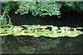
Water-lilies and Reflections
The water of the canal here is mirror-calm, reflecting the leaves of the sycamore trees above the white water-lilies.
Image: © Anne Burgess
Taken: 25 Jun 2019
0.04 miles
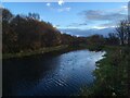
5
![Forth and Clyde Canal [26]](https://s0.geograph.org.uk/geophotos/06/24/92/6249248_56600f30_120x120.jpg)
Forth and Clyde Canal [26]
The traffic cones in the canal ensure that the fish keep in the correct lane.
The Forth and Clyde Canal was completed in 1790 and it provided a route for vessels between the Firth of Forth and the Firth of Clyde at the narrowest part (35 miles, 56km) of the Scottish Lowlands. Closed in 1963, the canal became semi-derelict. Millennium funds were used to regenerate the canal. The Glasgow Branch of the canal is a Scheduled Monument with details at: http://portal.historicenvironment.scot/designation/SM6771
Image: © Michael Dibb
Taken: 25 Jun 2019
0.07 miles
7

White Water-lily (Nymphaea alba)
Most of the clumps of these are on the far side of the canal, but there were a few close enough to the towpath to photograph.
Image: © Anne Burgess
Taken: 25 Jun 2019
0.10 miles
8
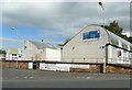
Industrial units, Chapel Street
Part of the Chapel Street Industrial Estate.
Image: © Richard Sutcliffe
Taken: 13 Sep 2021
0.10 miles
9
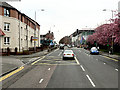
Maryhill Road
An older building, near the police station, home to a politician and the Politician bar.
Image: © Thomas Nugent
Taken: 19 Mar 2016
0.10 miles
10
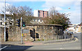
Maryhill Barracks wall
A surviving section of the perimeter wall of the barracks which were demolished in the early 1960s https://en.wikipedia.org/wiki/Maryhill_Barracks .
See the plaque on the wall here Image
Image: © Thomas Nugent
Taken: 19 Mar 2016
0.10 miles