IMAGES TAKEN NEAR TO
Kirkhill Drive, GLASGOW, G20 8JA
Introduction
This page details the photographs taken nearby to Kirkhill Drive, G20 8JA by members of the Geograph project.
The Geograph project started in 2005 with the aim of publishing, organising and preserving representative images for every square kilometre of Great Britain, Ireland and the Isle of Man.

There are currently over 7.5m images from over14,400 individuals and you can help contribute to the project by visiting https://www.geograph.org.uk
Image Map
Images are licensed for reuse under creativecommons.org/licenses/by-sa/2.0
Notes
- Clicking on the map will re-center to the selected point.
- The higher the marker number, the further away the image location is from the centre of the postcode.
Image Listing (105 Images Found)
Images are licensed for reuse under creativecommons.org/licenses/by-sa/2.0
Image
Details
Distance
2
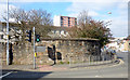
Maryhill Barracks wall
A surviving section of the perimeter wall of the barracks which were demolished in the early 1960s https://en.wikipedia.org/wiki/Maryhill_Barracks .
See the plaque on the wall here Image
Image: © Thomas Nugent
Taken: 19 Mar 2016
0.07 miles
3
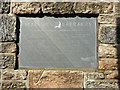
Maryhill Barracks commemorative plaque
On a surviving section of the perimeter wall at the corner of Maryhill Road and Garrioch Road Image
The plaque reads as follows...
MARYHILL BARRACKS
This plaque marks the site of Maryhill Barracks built in 1877 from local stone.
During its existence many Scottish Regiments and other military units
were stationed at Maryhill.
On 16th March 1921 the depot of the Highland Light Infantry, later to become
The City Of Glasgow Regiment, moved to Maryhill Barracks from Hamilton.
The last soldiers to be trained here left on 26 September 1958.
On 21 January 1959 the Highland Light Infantry amalgamated with The
Royal Scots Fusiliers to continue service as The Royal Highland Fusiliers
(Princess Margaret's Own Glasgow And Ayrshire Regiment).
Maryhill Barracks was demolished in 1961.
Strathclyde Regional Council
Plaque presented by Strathclyde Regional Council in 1989 during reconstruction of the wall.
Image: © Thomas Nugent
Taken: 19 Mar 2016
0.07 miles
4
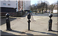
Wyndford wall bollards
These three bollards bear the date 1875 and are in a former gateway in the surviving section of the perimeter wall of Maryhill Barracks at Maryhill Road.
Image: © Thomas Nugent
Taken: 19 Mar 2016
0.08 miles
6
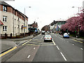
Maryhill Road
An older building, near the police station, home to a politician and the Politician bar.
Image: © Thomas Nugent
Taken: 19 Mar 2016
0.09 miles
7
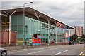
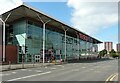
Tesco Extra store on Maryhill Road, Glasgow
Tesco Extra store located on Maryhill Road in Glasgow. This store is located in the North part of the city in the G20 post code zone.
Image: © Garry Cornes
Taken: 27 Jul 2018
0.11 miles
8
Maryhill Road station
On Maryhill Road. TV detective Jim Taggart http://www.imdb.com/title/tt0088621/ was based at Maryhill CID, but the police station used for the filming was in nearby Partick.
Image: © Thomas Nugent
Taken: 19 Mar 2016
0.11 miles
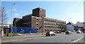
10
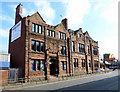
Former Glasgow Soldiers Home
At 1226-1236 Maryhill Road.
Image: © Thomas Nugent
Taken: 19 Mar 2016
0.12 miles