IMAGES TAKEN NEAR TO
Carrbridge Drive, GLASGOW, G20 8HH
Introduction
This page details the photographs taken nearby to Carrbridge Drive, G20 8HH by members of the Geograph project.
The Geograph project started in 2005 with the aim of publishing, organising and preserving representative images for every square kilometre of Great Britain, Ireland and the Isle of Man.

There are currently over 7.5m images from over14,400 individuals and you can help contribute to the project by visiting https://www.geograph.org.uk
Image Map
Images are licensed for reuse under creativecommons.org/licenses/by-sa/2.0
Notes
- Clicking on the map will re-center to the selected point.
- The higher the marker number, the further away the image location is from the centre of the postcode.
Image Listing (74 Images Found)
Images are licensed for reuse under creativecommons.org/licenses/by-sa/2.0
Image
Details
Distance
1
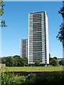
High flats at Wyndford Road
The photograph was taken from the Kelvin Walkway. The buildings date from the 1960s.
Image: © Lairich Rig
Taken: 30 Aug 2010
0.11 miles
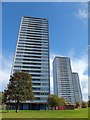
3
High flats on Wyndfiord Road
Looking down Kelvindale Road from Cleveden Road towards the tower blocks.
Image: © Richard Sutcliffe
Taken: 18 Oct 2018
0.13 miles
4

St. Gregory's, Wyndford
Dates from 1963-71. The architects were Thomas Cordiner, Cunningham and partners.
Image: © Jonathan Thacker
Taken: 21 Jul 2013
0.14 miles
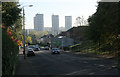
5

The River Kelvin and Wyndford high-rises
The piers in the river mark the site of a bridge on a branch of the Lanarkshire and Dumbartonshire Railway which served Temple Gasworks.
Image: © Jonathan Thacker
Taken: 21 Jul 2013
0.16 miles
6
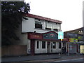
Elephant and Bugle, Maryhill
On Maryhill Road.
Image: © Stephen Sweeney
Taken: 3 Sep 2007
0.18 miles
7
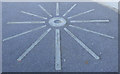
Pavement art in Maryhill
Part of the public realm improvements in front of Maryhill Burgh Hall. Terminus No 23 includes the names of local landmarks and features.
Image: © Thomas Nugent
Taken: 19 Mar 2016
0.18 miles
8
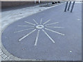
Pavement art in Maryhill
Part of the public realm improvements in front of Maryhill Burgh Hall. Terminus No 23 includes the names of local landmarks and features.
Image: © Thomas Nugent
Taken: 19 Mar 2016
0.18 miles
9
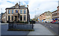
Maryhill Burgh Hall
A Category B Listed building http://portal.historic-scotland.gov.uk/designation/LB32349 off Maryhill Road at Gairbraid Avenue.
What appears to be the blocked-up entrance to a former public toilet is in the foreground.
Image: © Thomas Nugent
Taken: 19 Mar 2016
0.18 miles
10
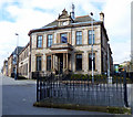
Maryhill Burgh Hall
A Category B Listed building http://portal.historic-scotland.gov.uk/designation/LB32349 off Maryhill Road at Gairbraid Avenue.
What appears to be the blocked-up entrance to a former public toilet is in the foreground.
Image: © Thomas Nugent
Taken: 19 Mar 2016
0.18 miles