IMAGES TAKEN NEAR TO
Acre Drive, GLASGOW, G20 0TP
Introduction
This page details the photographs taken nearby to Acre Drive, G20 0TP by members of the Geograph project.
The Geograph project started in 2005 with the aim of publishing, organising and preserving representative images for every square kilometre of Great Britain, Ireland and the Isle of Man.

There are currently over 7.5m images from over14,400 individuals and you can help contribute to the project by visiting https://www.geograph.org.uk
Image Map
Images are licensed for reuse under creativecommons.org/licenses/by-sa/2.0
Notes
- Clicking on the map will re-center to the selected point.
- The higher the marker number, the further away the image location is from the centre of the postcode.
Image Listing (88 Images Found)
Images are licensed for reuse under creativecommons.org/licenses/by-sa/2.0
Image
Details
Distance
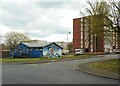
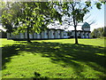
1
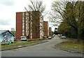
Acre Drive
Three blocks of flats on Acre Drive.
Image: © Richard Sutcliffe
Taken: 10 Apr 2022
0.01 miles
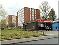
2
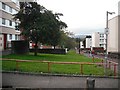
Acre Road flats
A series of residential blocks between Maryhill Park and the West of Scotland Science Campus.
Image: © Richard Webb
Taken: 26 Sep 2009
0.01 miles
3
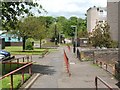
Path through Acre
Like the rest of Maryhill, the area that is now called Acre lies in what was originally the northern part of the old Gairbraid estate. Through his wife (the eponymous Mary Hill), Robert Graham came to acquire these lands; after a failed attempt to make money in the coal industry, he sold off some of his wife's lands, but "the part of Maryhill known as Acre was once the acre of ground which Graham held back from a sale in order to 'big colliers' houses'" [quotation from the book "Villages of Glasgow – North of the Clyde" by Aileen Smart; see that work for more on all of the above; note that in the quotation, "to big" means "to build/erect"].
For a wider view of this area, see Image
Image: © Lairich Rig
Taken: 3 Jun 2005
0.06 miles
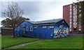
5
Acre Community Hall
With flats on Acre Drive.
Image: © Richard Sutcliffe
Taken: 10 Apr 2022
0.06 miles
6
Convenience store
Usave convenience store at the end of Acre Road. The flats behind are on Acre Drive.
Image: © Richard Sutcliffe
Taken: 10 Apr 2022
0.07 miles
7
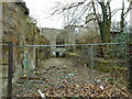
Ruins of Acre House
The late 19th century house with 1960s additions has been empty for a long time and was put up for sale in 2005. It has seriously deteriorated since then and has been fire-damaged as well. Listed Building Consent for a residential development was being sought in 2020. The property is category C listed http://portal.historicenvironment.scot/designation/LB33727 and is also on the BARRS register https://www.buildingsatrisk.org.uk/details/906575.
Image: © Richard Sutcliffe
Taken: 10 Apr 2022
0.07 miles
8
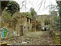
Ruins of Acre House
Viewed through a hole in the boundary wall. The late 19th century house with 1960s additions has been empty for a long time and was put up for sale in 2005. It has seriously deteriorated since then and has been fire-damaged as well. Listed Building Consent for a residential development was being sought in 2020. The property is category C listed http://portal.historicenvironment.scot/designation/LB33727 and is also on the BARRS register https://www.buildingsatrisk.org.uk/details/906575.
Image: © Richard Sutcliffe
Taken: 10 Apr 2022
0.07 miles
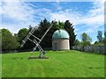
10
Glasgow University Observatory
This is the main observatory ('Acre Road'), close to the Garscube Estate.
In the 1970s, the observatory was virtually on its own, almost in open countryside. Now it is not so easy to locate, being surrounded by flats and office blocks.
For more information about Glasgow University Observatories, see http://www.astro.gla.ac.uk/observatory/observ.shtml
Image: © G Laird
Taken: 25 Sep 2010
0.08 miles