IMAGES TAKEN NEAR TO
Skaethorn Road, GLASGOW, G20 0TA
Introduction
This page details the photographs taken nearby to Skaethorn Road, G20 0TA by members of the Geograph project.
The Geograph project started in 2005 with the aim of publishing, organising and preserving representative images for every square kilometre of Great Britain, Ireland and the Isle of Man.

There are currently over 7.5m images from over14,400 individuals and you can help contribute to the project by visiting https://www.geograph.org.uk
Image Map
Images are licensed for reuse under creativecommons.org/licenses/by-sa/2.0
Notes
- Clicking on the map will re-center to the selected point.
- The higher the marker number, the further away the image location is from the centre of the postcode.
Image Listing (63 Images Found)
Images are licensed for reuse under creativecommons.org/licenses/by-sa/2.0
Image
Details
Distance
1
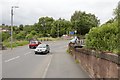
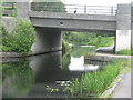
Bridges carrying Cleveden Road
The bridge in the foreground goes over a disused railway line. The next bridge is for the Forth and Clyde Canal.
Image: © Mark Anderson
Taken: 25 Jun 2019
0.02 miles
2
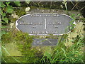
Forth & Clyde Canal distance marker
Just to the east of the Cleveden Road Bridge.
Image: © M J Richardson
Taken: 25 Jun 2019
0.03 miles
3
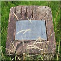
Memorial plaque
At the entrance to Kelvindale Station.
Kelvindale Station
Officially opened
by
Bill Butler MSP
and
Councillor Alistair Watson
Chair, Strathclyde Passenger Transport Authority
on
Wednesday, September 28th, 2005
Image: © Richard Sutcliffe
Taken: 8 Aug 2024
0.03 miles
4
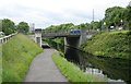
Bridge over the Forth and Clyde Canal
Originally there was a bascule bridge here carrying Clevedon Road over the canal. It was replaced by a brick built culvert in 1968 after the canal has closed to traffic. The current bridge replaced this in the 1990s in preparation for the re-opening of the canal in 2001.
The sign for Kelvindale Station (on the Anniesland to Glasgow Queen Street line) is on the right. In the distance on the left is one of the two remaining gas holders from Temple Gasworks, which are Category B listed http://portal.historicenvironment.scot/designation/LB52443.
Image: © Richard Sutcliffe
Taken: 25 Jun 2019
0.04 miles
5
![Forth and Clyde Canal [46]](https://s1.geograph.org.uk/geophotos/06/24/97/6249773_59af58d0_120x120.jpg)
Forth and Clyde Canal [46]
The Govan Cottage Bridge carries Cleveden Road over the canal. It was originally a bascule bridge and was later culverted. It remained culverted until 1997. The construction date of the current bridge is not known.
The Forth and Clyde Canal was completed in 1790 and it provided a route for vessels between the Firth of Forth and the Firth of Clyde at the narrowest part (35 miles, 56km) of the Scottish Lowlands. Closed in 1963, the canal became semi-derelict. Millennium funds were used to regenerate the canal. The main line of the canal is a Scheduled Monument with details at: http://portal.historicenvironment.scot/designation/SM6773
Image: © Michael Dibb
Taken: 25 Jun 2019
0.04 miles
6
The Forth & Clyde Canal at Kelvindale
Passing under Cleveden Road.
Image: © M J Richardson
Taken: 25 Jun 2019
0.04 miles
7
Old garages
Off Clevenden Road. See Image for a different view.
Image: © Richard Sutcliffe
Taken: 8 Aug 2024
0.04 miles
8
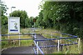
Path to Kelvindale Station
A zig-zag path from Clevenden Road down to the platform of Kelvindale Station.
Image: © Richard Sutcliffe
Taken: 8 Aug 2024
0.04 miles
9
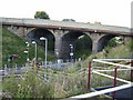
Road viaduct over railway line
At Kelvindale station.
Image: © Stephen Sweeney
Taken: 3 Sep 2007
0.05 miles
10
Old gradient sign at Kelvindale railway station
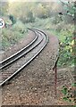
The sign is just outside the station, under the Dalsholm Road bridge.
Image: © Thomas Nugent
Taken: 31 Oct 2023
0.05 miles