IMAGES TAKEN NEAR TO
Cranbrooke Drive, GLASGOW, G20 0LT
Introduction
This page details the photographs taken nearby to Cranbrooke Drive, G20 0LT by members of the Geograph project.
The Geograph project started in 2005 with the aim of publishing, organising and preserving representative images for every square kilometre of Great Britain, Ireland and the Isle of Man.

There are currently over 7.5m images from over14,400 individuals and you can help contribute to the project by visiting https://www.geograph.org.uk
Image Map
Images are licensed for reuse under creativecommons.org/licenses/by-sa/2.0
Notes
- Clicking on the map will re-center to the selected point.
- The higher the marker number, the further away the image location is from the centre of the postcode.
Image Listing (160 Images Found)
Images are licensed for reuse under creativecommons.org/licenses/by-sa/2.0
Image
Details
Distance
1
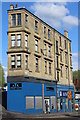
Hughes Memorial Orange Halls
The white-coloured building is the Hughes Memorial Orange Halls on Sandbank Street - home to LOL Maryhill Orange & Purple District 46 and Sandbank Social Club.
Image: © Richard Sutcliffe
Taken: 25 Jun 2019
0.15 miles
2
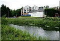
New houses on Sandbank Street
Seen from across the canal. For the plainer building in front of them, see Image
Image: © Stephen Craven
Taken: 25 Jun 2019
0.16 miles
3
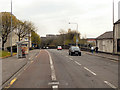
Maryhill Road from Maryhill Top Locks
Image: © Alec MacKinnon
Taken: 27 Jun 2023
0.16 miles
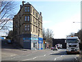
4
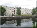
Flats on Maryhill Road, Glasgow
On the A81, with all the appearance of the architectural flair of the 1960's.
Image: © M J Richardson
Taken: 25 Jun 2019
0.17 miles
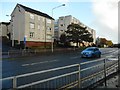
5
Maryhill Road, Glasgow
At the corner of Sandbank Street
Image: © Leslie Barrie
Taken: 29 Apr 2014
0.18 miles
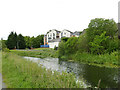
7
Maryhill Road at Sandbank Street
Sandbank Street is to the left of the tenement which is built on the gushet (triangular piece of land) at the junction of the two roads. The bridge on the right carries the Forth and Clyde Canal over Maryhill Road.
Image: © Thomas Nugent
Taken: 19 Mar 2016
0.18 miles
9
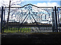
The Forth and Clyde Canal at Maryhill
Fairly new looking canal themed fence alongside Maryhill Road. This section of the fence has a Soviet look to it, with workers marching towards the factories.
Image: © Thomas Nugent
Taken: 19 Mar 2016
0.18 miles
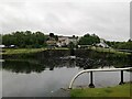
10
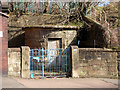
Valve house on Maryhill Road
Adjacent to the water pumping station Image
Image: © Thomas Nugent
Taken: 19 Mar 2016
0.18 miles