IMAGES TAKEN NEAR TO
Kilmun Street, GLASGOW, G20 0EL
Introduction
This page details the photographs taken nearby to Kilmun Street, G20 0EL by members of the Geograph project.
The Geograph project started in 2005 with the aim of publishing, organising and preserving representative images for every square kilometre of Great Britain, Ireland and the Isle of Man.

There are currently over 7.5m images from over14,400 individuals and you can help contribute to the project by visiting https://www.geograph.org.uk
Image Map
Images are licensed for reuse under creativecommons.org/licenses/by-sa/2.0
Notes
- Clicking on the map will re-center to the selected point.
- The higher the marker number, the further away the image location is from the centre of the postcode.
Image Listing (89 Images Found)
Images are licensed for reuse under creativecommons.org/licenses/by-sa/2.0
Image
Details
Distance
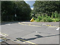
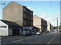
1
Maryhill Road (A81)
Looking roughly SSE along Maryhill Road (A81), just outside Maryhill railway station.
Image: © Andrew Reid
Taken: 2 Sep 2011
0.04 miles
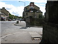
2
Craigieburn Gardens, Maryhill
Looking roughly WSW down Craigieburn Gardens near to Maryhill railway station. The photo was taken from the junction at Maryhill Road.
Image: © Andrew Reid
Taken: 2 Sep 2011
0.04 miles
3
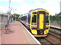
Summerston railway station, looking West
Looking roughly west at Summerston railway station, with a train (158 735) departing with the 10:37 service to Anniesland.
Image: © Andrew Reid
Taken: 14 Aug 2006
0.04 miles
5
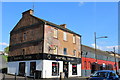
Maryhill Tavern, Maryhill Road, Glasgow
Image: © Leslie Barrie
Taken: 29 Apr 2014
0.10 miles
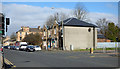
6
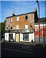
Maryhill Tavern, Maryhill Road
Boarded up and empty.
Image: © Richard Sutcliffe
Taken: 3 Sep 2018
0.10 miles
7
Former Maryhill Tavern
The former public house is deteriorating. Compare with an earlier view Image
Image: © Richard Sutcliffe
Taken: 13 Sep 2021
0.10 miles
8
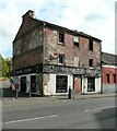
Former Maryhill Tavern
The former public house on Maryhill Road is deteriorating.
Image: © Richard Sutcliffe
Taken: 13 Sep 2021
0.10 miles
9
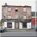
Former Maryhill Tavern
Still deteriorating Image
Image: © Richard Sutcliffe
Taken: 25 Jul 2024
0.10 miles
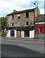
10
Maryhill Road
Identified on 19thC maps as Main Street, Maryhill.
Image: © Jim Smillie
Taken: 9 Sep 2009
0.10 miles