IMAGES TAKEN NEAR TO
Innellan Gardens, GLASGOW, G20 0DX
Introduction
This page details the photographs taken nearby to Innellan Gardens, G20 0DX by members of the Geograph project.
The Geograph project started in 2005 with the aim of publishing, organising and preserving representative images for every square kilometre of Great Britain, Ireland and the Isle of Man.

There are currently over 7.5m images from over14,400 individuals and you can help contribute to the project by visiting https://www.geograph.org.uk
Image Map
Images are licensed for reuse under creativecommons.org/licenses/by-sa/2.0
Notes
- Clicking on the map will re-center to the selected point.
- The higher the marker number, the further away the image location is from the centre of the postcode.
Image Listing (91 Images Found)
Images are licensed for reuse under creativecommons.org/licenses/by-sa/2.0
Image
Details
Distance
1
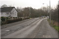
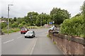
Cowal Road
Depending which map you look at, this is either Cowal Road or Skaethorn Road. There is a roundabout at the top of the hill.
Image: © Richard Sutcliffe
Taken: 24 Mar 2016
0.04 miles
3
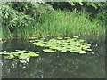
The Forth & Clyde Canal
Yellow Water-lily [Nuphar lutea], and canal-side vegetation near Maryhill.
Image: © M J Richardson
Taken: 25 Jun 2019
0.08 miles
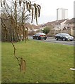
5
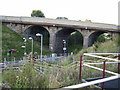
Bridges carrying Cleveden Road
The bridge in the foreground goes over a disused railway line. The next bridge is for the Forth and Clyde Canal.
Image: © Mark Anderson
Taken: 25 Jun 2019
0.11 miles
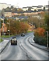
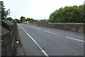
6
Road viaduct over railway line
At Kelvindale station.
Image: © Stephen Sweeney
Taken: 3 Sep 2007
0.11 miles
8
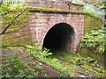
![Forth and Clyde Canal [45]](https://s0.geograph.org.uk/geophotos/06/24/97/6249748_6b437ab2_120x120.jpg)
Forth and Clyde Canal [45]
The portal of a dismantled railway tunnel alongside the towpath.
The Forth and Clyde Canal was completed in 1790 and it provided a route for vessels between the Firth of Forth and the Firth of Clyde at the narrowest part (35 miles, 56km) of the Scottish Lowlands. Closed in 1963, the canal became semi-derelict. Millennium funds were used to regenerate the canal. The main line of the canal is a Scheduled Monument with details at: http://portal.historicenvironment.scot/designation/SM6773
Image: © Michael Dibb
Taken: 25 Jun 2019
0.11 miles
9
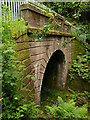
Western portal of Kelvindale tunnel
The tunnel was on an industrial branch railway that left the Caledonian line at Maryhill, crossed the River Kelvin on a viaduct of which only the piers remain Image, through this tunnel and on to the Temple gasworks that closed in 1968 Image
Image: © Stephen Craven
Taken: 25 Jun 2019
0.11 miles
10
Dalsholm Road bridge
The bridge crosses the railway above Kelvindale Station.
Image: © Richard Sutcliffe
Taken: 8 Aug 2024
0.11 miles