IMAGES TAKEN NEAR TO
Osborne Street, GLASGOW, G1 5QN
Introduction
This page details the photographs taken nearby to Osborne Street, G1 5QN by members of the Geograph project.
The Geograph project started in 2005 with the aim of publishing, organising and preserving representative images for every square kilometre of Great Britain, Ireland and the Isle of Man.

There are currently over 7.5m images from over14,400 individuals and you can help contribute to the project by visiting https://www.geograph.org.uk
Image Map (Loading...)


Getting Data...Please wait
Leaflet Map data © OpenStreetMap
Images are licensed for reuse under creativecommons.org/licenses/by-sa/2.0
Notes
- Clicking on the map will re-center to the selected point.
- The higher the marker number, the further away the image location is from the centre of the postcode.
Image Listing (1612 Images Found)
Images are licensed for reuse under creativecommons.org/licenses/by-sa/2.0
Image
Details
Distance
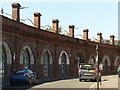
1
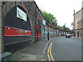
Osborne Street railway arches
The line forks on the arches in the foreground, ending in a dead end which can be seen in the distance. The out of sight left branch of the fork is the still active City Union line which continues south to cross the Clyde and into the Gorbals.
Image: © Thomas Nugent
Taken: 21 Jul 2012
0.02 miles
2
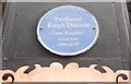
Photographing the future?
I'm not really sure whether or not I've taken this picture yet.
Blue plaque to Professor Ralph Deeson at 45 King Street, see Image
Image: © Barbara Carr
Taken: 22 Sep 2013
0.02 miles
3
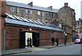
The Modern Institute
An art gallery in a former bath house on Osborne Street http://www.themoderninstitute.com/ .
Image: © Thomas Nugent
Taken: 10 Mar 2012
0.02 miles
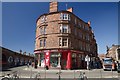
4
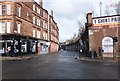
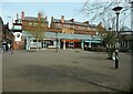
Osborne Street, Glasgow
At the junction with King Street.
Image: © Barbara Carr
Taken: 17 Apr 2013
0.02 miles
5
Railway arches, Osborne Street
Part of the curve leading into the former St Enoch Station from the east which after the early years never carried regular passenger services.
Image: © Alan Murray-Rust
Taken: 27 Jun 2019
0.02 miles
6
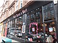
"Once upon a Tart", 45 King Street
Quirky café with delicious baked treats. There is a blue plaque to Professor Ralph Deeson, see Image
Image: © Barbara Carr
Taken: 22 Sep 2013
0.03 miles
7
Osborne Street and Parnie Street
Maps from the late 19th century show this as open space called Saltmarket Junction. By the early 20th century, the building in the foreground had been built and the roads either side came together in a junction with Saltmarket. Now the junction has been blocked off and the two roads meet in the middle of this sharp bend.
Image: © Mark Anderson
Taken: 27 Jun 2019
0.03 miles
8
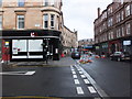
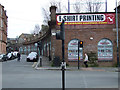
Chisholm Street
At the junction with Parnie Street.
Image: © Barbara Carr
Taken: 17 Apr 2013
0.03 miles
9
Kings Court
Some of the shops built under the arches of the former railway viaduct.
Image: © Richard Sutcliffe
Taken: 28 Apr 2022
0.03 miles
10
Old railway viaduct
On Osborne Street at King Street. The viaduct carried the lines from the north into St Enoch station which was demolished in the late 1960s.
Image: © Thomas Nugent
Taken: 10 Mar 2012
0.03 miles