IMAGES TAKEN NEAR TO
Steel Street, GLASGOW, G1 5PT
Introduction
This page details the photographs taken nearby to Steel Street, G1 5PT by members of the Geograph project.
The Geograph project started in 2005 with the aim of publishing, organising and preserving representative images for every square kilometre of Great Britain, Ireland and the Isle of Man.

There are currently over 7.5m images from over14,400 individuals and you can help contribute to the project by visiting https://www.geograph.org.uk
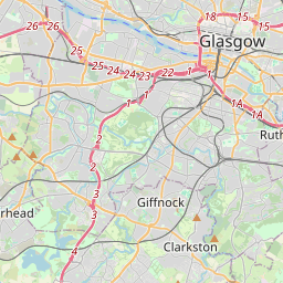
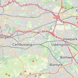
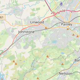
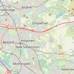
Image Map (1412 Images)

Leaflet Map data © OpenStreetMap
Images are licensed for reuse under creativecommons.org/licenses/by-sa/2.0
Notes
- Clicking on the map will re-center to the selected point.
- The higher the marker number, the further away the image location is from the centre of the postcode.
Image Listing (1412 Images Found)
Images are licensed for reuse under creativecommons.org/licenses/by-sa/2.0
Image
Details
Distance
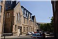
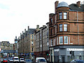
1
Refurbished old building in Steel Street
Image: © Gordon Brown
Taken: 27 Jun 2019
0.01 miles
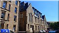
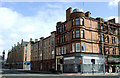
2
Converted building on Steel Street
This building looks like it may once have been a school (or Sunday school). It has been converted into flats with 2 floors added in the roof space.
Image: © Mark Anderson
Taken: 27 Jun 2019
0.02 miles
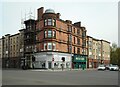
3
![Glasgow buildings [91]](https://s3.geograph.org.uk/geophotos/06/25/94/6259467_f584fe07_120x120.jpg)
Glasgow buildings [91]
Now converted into houses, this large building was Tent Hall. The hall was built in 1876 for the United Evangelical Association who were part of the temperance movement. The Association offered alternative entertainment to the usual Saturday night drinking. The building was extended in 1900 and in 1931. There are further details at: https://www.lostglasgow.scot/posts/signing-the-pledge-in-tent-hall-321/ The hall is listed, category B, with details at: http://portal.historicenvironment.scot/designation/LB32791
Image: © Michael Dibb
Taken: 27 Jun 2019
0.02 miles
4
Saltmarket at Greendyke Street
Looking towards the Tolbooth Steeple at Glasgow Cross.
Image: © Thomas Nugent
Taken: 15 Apr 2013
0.02 miles
5
Saltmarket at Greendyke Street
Looking towards the Tolbooth Steeple at Glasgow Cross.
Image: © Thomas Nugent
Taken: 15 Apr 2013
0.02 miles
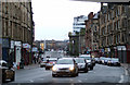
6
Corner of Saltmarket and Greendyke Street
Image: © Richard Sutcliffe
Taken: 28 Apr 2022
0.02 miles
7
Saltmarket
Looking towards Glasgow Green and the River Clyde. The columns on the right are at the High Court. The modern building beyond it is the nautical college.
Image: © Thomas Nugent
Taken: 26 Jan 2013
0.02 miles
8
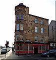
Ship Bank Buildings
At the corner of Bridgegate (right) and Saltmarket. Dated 1904, home to the Ship Bank Bar on the ground floor.
Image: © Thomas Nugent
Taken: 28 Feb 2016
0.03 miles
9
![Glasgow buildings [89]](https://s2.geograph.org.uk/geophotos/06/25/87/6258782_3d1eef8c_120x120.jpg)
Glasgow buildings [89]
This was the site Glasgow's first bank The Ship Bank on the corner of Saltmarket and Bridgegate. The bank was founded in 1750 by a group of Glasgow's leading Tobacco Lords. The bank subsequently moved to new premises the building was used for shops and dwellings. In 1845 a public house opened on the ground floor. The premises were rebuilt in 1904 and the corner tower and cupola became a landmark.
Image: © Michael Dibb
Taken: 27 Jun 2019
0.03 miles
10
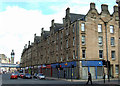
City Improvement Trust tenemants on Saltmarket at Steel Street
These were the first City Improvement Trust tenements to be built. The date stones on the right read VR and 1887. Another date stone on the Saltmarket side also reads 1887 Image
Image: © Thomas Nugent
Taken: 15 Apr 2013
0.03 miles