IMAGES TAKEN NEAR TO
Watson Street, GLASGOW, G1 5AL
Introduction
This page details the photographs taken nearby to Watson Street, G1 5AL by members of the Geograph project.
The Geograph project started in 2005 with the aim of publishing, organising and preserving representative images for every square kilometre of Great Britain, Ireland and the Isle of Man.

There are currently over 7.5m images from over14,400 individuals and you can help contribute to the project by visiting https://www.geograph.org.uk
Image Map
Images are licensed for reuse under creativecommons.org/licenses/by-sa/2.0
Notes
- Clicking on the map will re-center to the selected point.
- The higher the marker number, the further away the image location is from the centre of the postcode.
Image Listing (1170 Images Found)
Images are licensed for reuse under creativecommons.org/licenses/by-sa/2.0
Image
Details
Distance
1
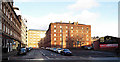
Watson Street
Off Gallowgate, leading to Bell Street. The prominent building is the Category B Listed http://data.historic-scotland.gov.uk/pls/htmldb/f?p=2200:15:0::::BUILDING:33816 former Glasgow Cleansing Department building which includes multi-storey stabling and horse ramps.
Image: © Thomas Nugent
Taken: 29 Dec 2013
0.02 miles
2
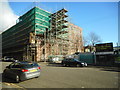
New homes coming soon
Development under way at the Category B listed [http://portal.historicenvironment.scot/designation/LB33816] former Glasgow Corporation Cleansing Department building at the corner of Bell Street and Watson Street.
Lowther Homes are converting the derelict building into 52 mid-market flats for social rent.
See [http://www.geograph.org.uk/photo/3814058] for a view of the building without the scaffolding.
Image: © Richard Sutcliffe
Taken: 2 Feb 2018
0.02 miles
3

Watson Street
Looking towards Bell Street from Gallowgate. The red brick building in the centre is the former stables of Glasgow Corporation's Cleansing Department, which is Category B Listed http://portal.historicenvironment.scot/designation/LB33816 .
anmore: https://canmore.org.uk/site/148308/glasgow-142-bell-street-cleansing-department-depot .
Image: © Thomas Nugent
Taken: 9 Feb 2019
0.03 miles
4
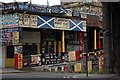
Market
The sign says St Andrew's Market but it wasn't opened for business. Situated in the Gallowgate.
Image: © Paul McIlroy
Taken: 13 Jul 2007
0.03 miles
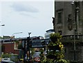
5
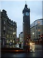
Tolbooth Steeple, Glasgow Cross
Last remnant of the Glasgow Tolbooth building, which housed Glasgow's jail and the Town Clerk's office.
Image: © Stephen Sweeney
Taken: 16 Dec 2008
0.03 miles
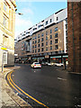
6
Gallowgate
Looking towards Glasgow Cross, Watson Street is on the right.
Image: © Thomas Nugent
Taken: 16 Sep 2017
0.03 miles
7
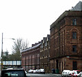
Bell Street railway stables
The Category B Listed red brick building was constructed as stables for the Glasgow and South-Western Railway around 1900.
Image: © Thomas Nugent
Taken: 15 Apr 2013
0.03 miles
8
High Street
The start of High Street at Glasgow Cross.
Image: © Thomas Nugent
Taken: 29 Dec 2013
0.03 miles
9
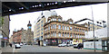
Gallowgate railway bridge
With the uncommon sight of a passenger train, presumably empty, since no passenger services use this route. Viewed from Glasgow Cross.
Image: © Thomas Nugent
Taken: 22 Aug 2009
0.03 miles
10

Gallowgate at Watson Street
Watson Street is on the right. The building on the corner is Category B Listed http://portal.historicenvironment.scot/designation/LB33861 . The Tolbooth Steeple at Glasgow Cross is on the left.
Image: © Thomas Nugent
Taken: 9 Feb 2019
0.03 miles