IMAGES TAKEN NEAR TO
Kinfauns Drive, GLASGOW, G15 7AH
Introduction
This page details the photographs taken nearby to Kinfauns Drive, G15 7AH by members of the Geograph project.
The Geograph project started in 2005 with the aim of publishing, organising and preserving representative images for every square kilometre of Great Britain, Ireland and the Isle of Man.

There are currently over 7.5m images from over14,400 individuals and you can help contribute to the project by visiting https://www.geograph.org.uk
Image Map
Images are licensed for reuse under creativecommons.org/licenses/by-sa/2.0
Notes
- Clicking on the map will re-center to the selected point.
- The higher the marker number, the further away the image location is from the centre of the postcode.
Image Listing (28 Images Found)
Images are licensed for reuse under creativecommons.org/licenses/by-sa/2.0
Image
Details
Distance
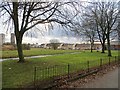
2
Public art, Drumchapel, Glasgow
Installed in 2009, this sculpture of Pegasus is by Andy Scott who is probably more famous for Image
Image: © Claire Pegrum
Taken: 22 May 2023
0.14 miles
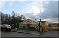
3
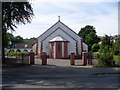
Church on Kinfauns Drive
At the corner of Achamore Road.
Image: © Stephen Sweeney
Taken: 24 Jul 2008
0.15 miles
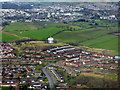
4
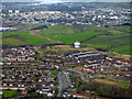
Drumchapel from the air
The landmark water tower can be seen, as can Clydebank, the distant Erskine Bridge and River Clyde.
Image: © Thomas Nugent
Taken: 7 Apr 2016
0.15 miles
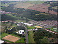
5
Drumchapel from the air
Looking along Achanmore Road towards the water tower, with Hardgate and Faifley in the background.
Image: © Thomas Nugent
Taken: 7 Apr 2016
0.16 miles
6
Drumchapel St Mark's Church of Scotland
Built 1955-6.
Image: © Leslie Barrie
Taken: 23 Aug 2014
0.16 miles
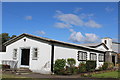
7
Orange Hall, Kinfauns Drive
Some strange gold coloured shapes on the fence.
Image: © Richard Webb
Taken: 19 Jan 2014
0.17 miles
9
St Clare's Primary School, Drumchapel
The wooded slope beyond is Garscadden Wood, and marks the boundary between Glasgow and East Dunbartonshire. The course of the Antonine Wall runs across the top of the image.
Image: © M J Richardson
Taken: 3 Oct 2015
0.18 miles
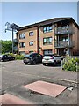
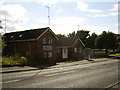
10
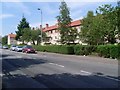
Flats on Kinfauns Drive
Recently renovated flats facing the park.
Image: © Stephen Sweeney
Taken: 24 Jul 2008
0.18 miles