IMAGES TAKEN NEAR TO
South Street, GLASGOW, G14 0TR
Introduction
This page details the photographs taken nearby to South Street, G14 0TR by members of the Geograph project.
The Geograph project started in 2005 with the aim of publishing, organising and preserving representative images for every square kilometre of Great Britain, Ireland and the Isle of Man.

There are currently over 7.5m images from over14,400 individuals and you can help contribute to the project by visiting https://www.geograph.org.uk
Image Map
Images are licensed for reuse under creativecommons.org/licenses/by-sa/2.0
Notes
- Clicking on the map will re-center to the selected point.
- The higher the marker number, the further away the image location is from the centre of the postcode.
Image Listing (54 Images Found)
Images are licensed for reuse under creativecommons.org/licenses/by-sa/2.0
Image
Details
Distance
1
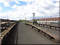
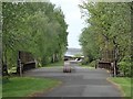
Lanarkshire and Dunbartonshire Railway
One of the roots of the Caledonian Railway, this is now closed and much of the trackbed is a cycle path - one of Sustrans' pioneering routes.
Image: © Richard Webb
Taken: 9 May 2012
0.02 miles
2
Cycleway at Whiteinch
"Dead" telegraph poles line the route as the tarmac of the Glasgow to Loch Lomond cycleway widens out across the Edzell Street and (in the background) Jordan Street underbridges at Whiteinch and new blocks of low-rise flats herald residential regeneration. In the far background four dockside cranes are now a relative rarity on Glasgow's Clydeside quays.
Image: © A-M-Jervis
Taken: 15 Dec 2007
0.02 miles
3
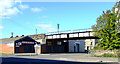
Old railway bridge
Crosses Jordan Street at South Street. Now part of the National Cycle Network, Route 7.
Image: © Thomas Nugent
Taken: 25 Sep 2010
0.04 miles
4
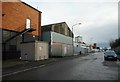
Jordanvale Avenue
Clydeside Industrial Estate.
Image: © Richard Sutcliffe
Taken: 20 Dec 2019
0.05 miles
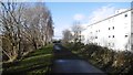
5
Former Caledonian "Riverside" railway line, between Whiteinch and Scotstoun
Now a footpath.
Image: © Nigel Thompson
Taken: 29 Apr 2019
0.07 miles
6
Jordanvale Avenue
Clydeside Industrial Estate.
Image: © Richard Sutcliffe
Taken: 20 Dec 2019
0.07 miles
7
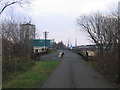
Lanarkshire and Dunbartonshire Railway
The trackbed is now looked after by Sustrans and forms part of Route 7 out of Glasgow though Clydebank and Dumbarton to Loch Lomond.
Image: © Richard Webb
Taken: 4 Jan 2016
0.07 miles
8
Whiteinch
Residential area surrounding Northinch Street.
Image: © Stephen Sweeney
Taken: 9 Aug 2007
0.08 miles
9
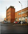
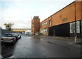
Industrial estate
Part of the Clydeside Industrial Estate at the corner of Jordanvale Avenue and Clydeholm Road.
Image: © Richard Sutcliffe
Taken: 20 Dec 2019
0.08 miles
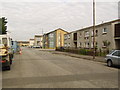
10
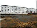
Southview Apartments
The flats on Curle Street were built in two phases. Those on the right were built around 2008; those on the left around 2023-2024. The vacant ground between them and Northinch Street will probably be built on at some stage in the future.
Image: © Richard Sutcliffe
Taken: 10 Feb 2025
0.10 miles