IMAGES TAKEN NEAR TO
Dyke Road, GLASGOW, G13 4PN
Introduction
This page details the photographs taken nearby to Dyke Road, G13 4PN by members of the Geograph project.
The Geograph project started in 2005 with the aim of publishing, organising and preserving representative images for every square kilometre of Great Britain, Ireland and the Isle of Man.

There are currently over 7.5m images from over14,400 individuals and you can help contribute to the project by visiting https://www.geograph.org.uk
Image Map
Images are licensed for reuse under creativecommons.org/licenses/by-sa/2.0
Notes
- Clicking on the map will re-center to the selected point.
- The higher the marker number, the further away the image location is from the centre of the postcode.
Image Listing (51 Images Found)
Images are licensed for reuse under creativecommons.org/licenses/by-sa/2.0
Image
Details
Distance
2
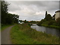
Forth Clyde Canal
Passing Old Drumchapel.
Image: © Richard Webb
Taken: 9 May 2012
0.09 miles
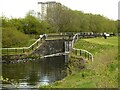
4
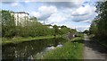
Forth & Clyde canal
Looking east from Lock 35 at Garscadden.
Image: © Thomas Nugent
Taken: 18 May 2008
0.11 miles
5
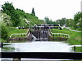
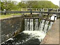
Forth & Clyde canal
Locks 35, 34 and 33 at garscadden.
Image: © Thomas Nugent
Taken: 18 May 2008
0.12 miles
7

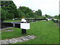
The Forth & Clyde canal at Garscadden
Locks 34 and 33 (Boghouse Middle and Boghouse Upper).
Image: © Thomas Nugent
Taken: 20 Aug 2022
0.14 miles
8

The Forth & Clyde Canal at Garscadden
Cyclists approaching Lock 34, Boghouse Middle Lock.
Image: © Thomas Nugent
Taken: 20 Aug 2022
0.14 miles
9

The Forth & Clyde Canal at Garscadden
Looking east from Lock 35 towards Lock 34.
Image: © Thomas Nugent
Taken: 20 Aug 2022
0.15 miles
10
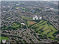
Knightswood from the air
Knightswood golf course is prominent, Scotstoun Stadium is at the top right and the A82 Great Western Road is towards the top left. The towerblocks in the centre are on Lincoln Avenue.
Image: © Thomas Nugent
Taken: 14 Sep 2015
0.16 miles