IMAGES TAKEN NEAR TO
Loanfoot Avenue, GLASGOW, G13 3DU
Introduction
This page details the photographs taken nearby to Loanfoot Avenue, G13 3DU by members of the Geograph project.
The Geograph project started in 2005 with the aim of publishing, organising and preserving representative images for every square kilometre of Great Britain, Ireland and the Isle of Man.

There are currently over 7.5m images from over14,400 individuals and you can help contribute to the project by visiting https://www.geograph.org.uk
Image Map
Images are licensed for reuse under creativecommons.org/licenses/by-sa/2.0
Notes
- Clicking on the map will re-center to the selected point.
- The higher the marker number, the further away the image location is from the centre of the postcode.
Image Listing (5 Images Found)
Images are licensed for reuse under creativecommons.org/licenses/by-sa/2.0
Image
Details
Distance
1
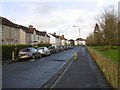
Loanfoot Avenue, Knightswood
Houses with a view over the golf course.
Image: © Richard Webb
Taken: 4 Jan 2016
0.10 miles
2
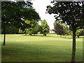
Knightswood Golf Club
A 9 hole parkland course.
Image: © Richard Webb
Taken: 4 Jan 2016
0.11 miles
3

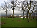
Knightswood Golf Course
Knightswood Golf Course is located just four miles west of Glasgow city centre. It is a 9 hole flat and open parkland course.
The Campsie Fells can be seen in the distance to the right in the photograph. To the left in the distance, a small part of the Kilpatrick Hills can also be seen between 2 of the tower blocks.
Image: © G Laird
Taken: 20 Mar 2010
0.16 miles
4
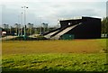
BMX track, Knightswood
Built between September 2017 and May 2018, the Glasgow BMX Centre was constructed for the European Championships in Glasgow. It is Scotland’s only World and Olympic standard BMX track.
Image: © Richard Sutcliffe
Taken: 13 Sep 2019
0.23 miles