IMAGES TAKEN NEAR TO
Kirkton Crescent, GLASGOW, G13 3AQ
Introduction
This page details the photographs taken nearby to Kirkton Crescent, G13 3AQ by members of the Geograph project.
The Geograph project started in 2005 with the aim of publishing, organising and preserving representative images for every square kilometre of Great Britain, Ireland and the Isle of Man.

There are currently over 7.5m images from over14,400 individuals and you can help contribute to the project by visiting https://www.geograph.org.uk
Image Map
Images are licensed for reuse under creativecommons.org/licenses/by-sa/2.0
Notes
- Clicking on the map will re-center to the selected point.
- The higher the marker number, the further away the image location is from the centre of the postcode.
Image Listing (11 Images Found)
Images are licensed for reuse under creativecommons.org/licenses/by-sa/2.0
Image
Details
Distance
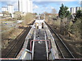
1
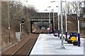
West view from the platform at Garscadden train station
View looking west from the platforms at Garscadden train station. The track on the left is the westbound track with the next station on the line being Yoker. The next eastbound station is Scotstounhill.
Image: © Garry Cornes
Taken: 27 Feb 2016
0.04 miles
2
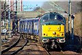
Class 314 being towed away for Scrap!
A Diesel Locomotive towes a Vintage Electric Multiple unit which has reached the end of the line in service.
The Class 314 entered service in 1979 and by the end of 2019, they will all be withdrawn from service after 40 years. This particular unit has been storage in Yoker Carriage Sidings after it was withdrawn and is now on its way to the scrapyard
Image: © Adam Forsyth
Taken: 13 Mar 2019
0.05 miles
3
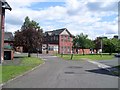
Grounds of Blawarthill Hospital
In the centre of the hospital grounds.
Image: © Stephen Sweeney
Taken: 15 Jun 2008
0.07 miles
4
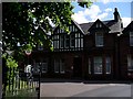
Blawarthill Hospital
Sixty-bed facitlity in the Yoker area of Glasgow. Specialises in the care of elderly patients.
Image: © Stephen Sweeney
Taken: 15 Jun 2008
0.09 miles
5
Garscadden railway station, Glasgow
Opened in 1960 by British Rail on the line from Glasgow to Dalmuir.
View south east towards Scotstounhill and Glasgow. The line was originally opened in 1882 by the Glasgow, Yoker and Clydebank Railway to Clydebank East, and extended 15 years later by the North British Railway to Dalmuir.
Image: © Nigel Thompson
Taken: 15 Mar 2013
0.10 miles
6
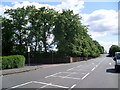
Corner of Dyke Road and Holehouse Drive
The wall on the corner is at the edge of the grounds of Blawarthill Hospital.
Image: © Stephen Sweeney
Taken: 15 Jun 2008
0.12 miles
7
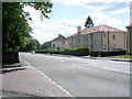
Dyke Road housing
From the corner of Holehouse Drive.
Image: © Stephen Sweeney
Taken: 15 Jun 2008
0.12 miles
8
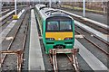
A London Midland Class 320 Electric Train at Yoker Depot
A Class 320 electric multiple unit train sits at Matthew House in Yoker. This train, (designated 320411), was recently purchased from London Midland for use in the Scotrail network but to date has not been used in active service. This electric multiple unit, (EMU), originally designated 321411 was previously a 4 car configuration Class 321 but has been converted to a 3 car Class 320. The green livery of London Midland has not been removed. The shot was taken through the fence on Dyke Road.
Image: © Garry Cornes
Taken: 27 Feb 2016
0.14 miles
9
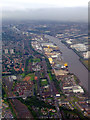
The Upper Clyde from the air
Yoker railway depot is at the lower left, BAE's Scotstoun shipyard is on the left bank of the Clyde, with Braehead shopping and leisure complex on the right, with the King George V Dock beyond.
Image: © Thomas Nugent
Taken: 16 Aug 2011
0.16 miles
10
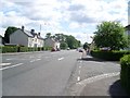
Dyke Road, Yoker
Runs from Archerhill Road down to Dumbarton Road. This section is just south of Alderman Road.
Image: © Stephen Sweeney
Taken: 15 Jun 2008
0.23 miles