IMAGES TAKEN NEAR TO
Wamba Place, GLASGOW, G13 2ND
Introduction
This page details the photographs taken nearby to Wamba Place, G13 2ND by members of the Geograph project.
The Geograph project started in 2005 with the aim of publishing, organising and preserving representative images for every square kilometre of Great Britain, Ireland and the Isle of Man.

There are currently over 7.5m images from over14,400 individuals and you can help contribute to the project by visiting https://www.geograph.org.uk
Image Map
Images are licensed for reuse under creativecommons.org/licenses/by-sa/2.0
Notes
- Clicking on the map will re-center to the selected point.
- The higher the marker number, the further away the image location is from the centre of the postcode.
Image Listing (39 Images Found)
Images are licensed for reuse under creativecommons.org/licenses/by-sa/2.0
Image
Details
Distance
2
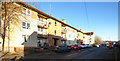
Wilverton Road
Wamba Avenue is just out of sight on the left.
Image: © Thomas Nugent
Taken: 31 Dec 2019
0.06 miles
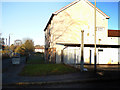
4
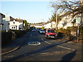
Cowdenhill Road
Wamba Avenue is on the left.
Image: © Thomas Nugent
Taken: 31 Dec 2019
0.08 miles
5

Handy Tam van
Handy Tam, your local handyman in the Knightswood area.
Facebook: https://www.facebook.com/handytamglasgow/ .
Image: © Thomas Nugent
Taken: 31 Dec 2019
0.08 miles
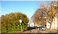
6
Rotherwood Avenue
Off Cowdenhill Road.
Image: © Thomas Nugent
Taken: 31 Dec 2019
0.09 miles
7

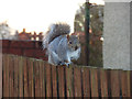
Squirrel on a fence
An urban grey squirrel, on a fence between houses on Avenel Road.
See also Image
Image: © Thomas Nugent
Taken: 31 Dec 2019
0.10 miles
8
Squirrel on a fence
An urban grey squirrel, on a fence between houses on Avenel Road.
See also Image
Image: © Thomas Nugent
Taken: 31 Dec 2019
0.10 miles
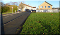
9
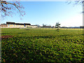
Netherton recreation ground
On the site of Knightswood brickworks, which closed in the early 1930s https://www.scottishbrickhistory.co.uk/knightswood-brickworks-knightswood-glasgow/ .
Image: © Thomas Nugent
Taken: 31 Dec 2019
0.12 miles
10
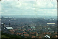
Lower Clyde Valley
The houses in the foreground are in Glendinning Rd and in the lower left of the image is part of the tow path of the Forth and Clyde Canal. In the distance can be seen the (now demolished) Meadowside Granary at Whiteinch with the Barclay Curle Titan crane to the right of it. Thanks to Thomas Nugent for the information.
Image: © Nigel Mykura
Taken: 19 Jul 2020
0.13 miles