IMAGES TAKEN NEAR TO
Chamberlain Road, GLASGOW, G13 1QE
Introduction
This page details the photographs taken nearby to Chamberlain Road, G13 1QE by members of the Geograph project.
The Geograph project started in 2005 with the aim of publishing, organising and preserving representative images for every square kilometre of Great Britain, Ireland and the Isle of Man.

There are currently over 7.5m images from over14,400 individuals and you can help contribute to the project by visiting https://www.geograph.org.uk
Image Map
Images are licensed for reuse under creativecommons.org/licenses/by-sa/2.0
Notes
- Clicking on the map will re-center to the selected point.
- The higher the marker number, the further away the image location is from the centre of the postcode.
Image Listing (41 Images Found)
Images are licensed for reuse under creativecommons.org/licenses/by-sa/2.0
Image
Details
Distance
1

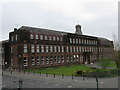
Jordanhill Training College Demonstration School
The lodge hides most of the frontage of the Category B listed http://portal.historicenvironment.scot/designation/LB32303 Demonstration School, which was built in 1913.
Image: © Richard Sutcliffe
Taken: 12 Jul 2021
0.07 miles
2
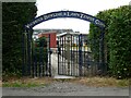
Woodend Bowling & Lawn Tennis Club
Entrance off Selborne Place. The club was established in 1908 and the first bowling green opened in 1909.
Image: © Richard Sutcliffe
Taken: 12 Jul 2021
0.07 miles

4
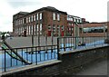
Jordanhill Training College Demonstration School
The Category B listed http://portal.historicenvironment.scot/designation/LB32303 Demonstration School was built in 1913. This view from Chamberlain Road shows the rear and side of the building. Image shows the front of the building.
Image: © Richard Sutcliffe
Taken: 12 Jul 2021
0.10 miles
5
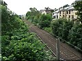
Railway line, Jordanhill
Seen from the Westbrae Drive bridge, looking towards Scotstoun.
Image: © Richard Sutcliffe
Taken: 12 Jul 2021
0.10 miles
6
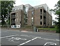
Jordanhill Park apartments
One of the new buildings in the New Jordanhill Park development by Cala Homes on the site of the former Education College.
Image: © Richard Sutcliffe
Taken: 12 Jul 2021
0.11 miles
7
Jordanhill School
Founded in 1920, it was formerly run by Jordanhill College of Education and was previously known as Jordanhill College School.
Image: © G Laird
Taken: 18 Apr 2009
0.11 miles
8
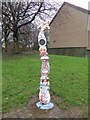
Millennium milepost, Westland Drive
Not on one of the numbered Sustrans routes but a waymarked cycle path which links further education sites in western Glasgow. A path runs along a disused section of the Whiteinch Railway from here.
Image: © Richard Webb
Taken: 19 Jan 2014
0.13 miles
9

Cycle path, Westland Drive
The path links educational sites in western Glasgow. From here a path runs along the trackbed of the Whiteinch Railway as well as towards Jordanhill.
Image: © Richard Webb
Taken: 19 Jan 2014
0.13 miles
10
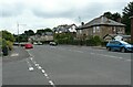
Southbrae Drive
Seen from the junction with Selborne Road.
Image: © Richard Sutcliffe
Taken: 12 Jul 2021
0.13 miles