IMAGES TAKEN NEAR TO
Bearsden Road, GLASGOW, G13 1EP
Introduction
This page details the photographs taken nearby to Bearsden Road, G13 1EP by members of the Geograph project.
The Geograph project started in 2005 with the aim of publishing, organising and preserving representative images for every square kilometre of Great Britain, Ireland and the Isle of Man.

There are currently over 7.5m images from over14,400 individuals and you can help contribute to the project by visiting https://www.geograph.org.uk
Image Map
Images are licensed for reuse under creativecommons.org/licenses/by-sa/2.0
Notes
- Clicking on the map will re-center to the selected point.
- The higher the marker number, the further away the image location is from the centre of the postcode.
Image Listing (160 Images Found)
Images are licensed for reuse under creativecommons.org/licenses/by-sa/2.0
Image
Details
Distance
1
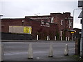
Watering Hole
The Anal Restaurant and Bar. Bearsden Road, Glasgow. The correct name for the premises is the Canal Restaurant and Bar but the C from the sign fell off shortly after the business closed permanently.
Image: © Tony Page
Taken: 15 Jan 2006
0.02 miles
2
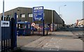
Entrance to Jewson
Builders' merchant on Bearsden Road.
Image: © Richard Sutcliffe
Taken: 12 Apr 2019
0.03 miles
3
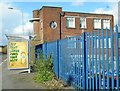
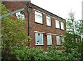
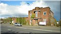
Former Canal restaurant
Originally built as offices for the Temple Saw Mills circa 1938, the building was converted into the Canal restaurant and microbrewery in 1998. By 2006 it was vacant and boarded up and has suffered from damage to windows and graffiti. It is Category C listed [http://portal.historicenvironment.scot/designation/LB32170] and is on the Buildings at Risk Register [https://www.buildingsatrisk.org.uk/search/keyword/anniesland/event_id/910674/building_name/canal-bar-restaurant-former-380-bearsden-road-anniesland].
Image: © Richard Sutcliffe
Taken: 27 Apr 2018
0.03 miles
4
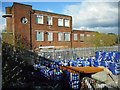
Former Canal restaurant
Originally built as offices for the Temple Saw Mills circa 1938, the building was converted into the Canal restaurant and microbrewery in 1998. By 2006 it was vacant and boarded up and has suffered from damage to windows and graffiti. It is Category C listed [http://portal.historicenvironment.scot/designation/LB32170] and is on the Buildings at Risk Register [https://www.buildingsatrisk.org.uk/search/keyword/anniesland/event_id/910674/building_name/canal-bar-restaurant-former-380-bearsden-road-anniesland].
The blue bags are in the yard of Jewsons next door.
Image: © Richard Sutcliffe
Taken: 27 Apr 2018
0.03 miles
5
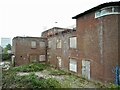
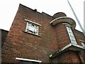
Due for demolition
The Category C listed http://portal.historicenvironment.scot/designation/LB32170 building, having been empty and deteriorating for several years, is to be demolished. The former Modern Movement office block was built in 1938 and was converted to the Canal Restaurant and microbrewery in 1998. 46 one and two bedroom flats are to be built on the site.
The metal bar on the left is part of a fence beside the building.
Image: © Richard Sutcliffe
Taken: 15 May 2022
0.03 miles
6
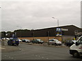
Jewson builder's merchants
On Bearsden Road, Anniesland.
Image: © Stephen Sweeney
Taken: 9 Aug 2007
0.03 miles
7
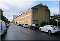
Tenement block, Crow Road
At the other end of the block there are shops on the ground floor.
Image: © Richard Sutcliffe
Taken: 13 Oct 2023
0.03 miles
8
Due for demolition
The Category C listed http://portal.historicenvironment.scot/designation/LB32170 building, having been empty and deteriorating for several years, is to be demolished. The former Modern Movement office block was built in 1938 and was converted to the Canal Restaurant and microbrewery in 1998. 46 one and two bedroom flats are to be built on the site.
Image: © Richard Sutcliffe
Taken: 15 May 2022
0.04 miles
9
Former Canal restaurant
Originally built as offices for the Temple Saw Mills circa 1938, the building was converted into the Canal restaurant and microbrewery in 1998. By 2006 it was vacant and boarded up and has suffered from damage to windows and graffiti. It is Category C listed [http://portal.historicenvironment.scot/designation/LB32170] and is on the Buildings at Risk Register [https://www.buildingsatrisk.org.uk/search/keyword/anniesland/event_id/910674/building_name/canal-bar-restaurant-former-380-bearsden-road-anniesland].
Image: © Richard Sutcliffe
Taken: 27 Apr 2018
0.04 miles
10
Due for demolition
The Category C listed http://portal.historicenvironment.scot/designation/LB32170 building, having been empty and deteriorating for several years, is to be demolished. The former Modern Movement office block was built in 1938 and was converted to the Canal Restaurant and microbrewery in 1998. 46 one and two bedroom flats are to be built on the site.
Image: © Richard Sutcliffe
Taken: 15 May 2022
0.04 miles