IMAGES TAKEN NEAR TO
Marchmont Terrace, GLASGOW, G12 9LT
Introduction
This page details the photographs taken nearby to Marchmont Terrace, G12 9LT by members of the Geograph project.
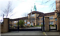
The Geograph project started in 2005 with the aim of publishing, organising and preserving representative images for every square kilometre of Great Britain, Ireland and the Isle of Man.

There are currently over 7.5m images from over14,400 individuals and you can help contribute to the project by visiting https://www.geograph.org.uk
Image Map
Images are licensed for reuse under creativecommons.org/licenses/by-sa/2.0
Notes
- Clicking on the map will re-center to the selected point.
- The higher the marker number, the further away the image location is from the centre of the postcode.
Image Listing (252 Images Found)
Images are licensed for reuse under creativecommons.org/licenses/by-sa/2.0
Image
Details
Distance
1
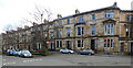
Observatory Road and Marchmount Terrace
Category B Listed http://portal.historicenvironment.scot/designation/LB32565 terraced houses. Viewed across Dundonald Road.
Image: © Thomas Nugent
Taken: 19 Mar 2017
0.03 miles
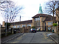
2
Notre Dame High School
This view shows the location of the school on a hilltop amongst the grand houses of the heart of the West End. This was the site of an observatory, which gave its name to Observatory Road, from where this photo was taken.
Image: © Thomas Nugent
Taken: 19 Mar 2017
0.06 miles
3
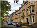
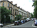
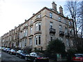
Hillhead terraced housing, Glasgow
Athole Gardens, seen here from Saltoun Street, mainly three-storey houses with attics and basements.
Image: © Paul Harrop
Taken: 25 Sep 2020
0.07 miles
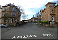
4
Notre Dame High School
The main gate of the school.
Image: © Thomas Nugent
Taken: 19 Mar 2017
0.07 miles
5
Notre Dame High School
A close view of the main gate, with the main school building beyond.
Image: © Thomas Nugent
Taken: 19 Mar 2017
0.07 miles
6
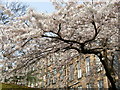
Cherry Tree in full Spring flower, plus backs of Observatory Road flats
Image: © roddyscot
Taken: 30 Mar 2007
0.07 miles
7
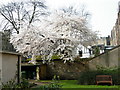
Cherry Tree in full spring flower, viewed from Saltoun Street
Image: © roddyscot
Taken: 30 Mar 2007
0.07 miles
8
Huntly Gardens
Category B Listed buildings http://data.historic-scotland.gov.uk/pls/htmldb/f?p=2200:15:0::::BUILDING:32529 . Looking up the hill from Saltoun Street.
Image: © Thomas Nugent
Taken: 27 Jul 2013
0.08 miles
10
Huntly Gardens
Houses dating from 1872-8.
Image: © Jonathan Thacker
Taken: 31 Mar 2016
0.09 miles