IMAGES TAKEN NEAR TO
Observatory Road, GLASGOW, G12 9LN
Introduction
This page details the photographs taken nearby to Observatory Road, G12 9LN by members of the Geograph project.
The Geograph project started in 2005 with the aim of publishing, organising and preserving representative images for every square kilometre of Great Britain, Ireland and the Isle of Man.

There are currently over 7.5m images from over14,400 individuals and you can help contribute to the project by visiting https://www.geograph.org.uk
Image Map
Images are licensed for reuse under creativecommons.org/licenses/by-sa/2.0
Notes
- Clicking on the map will re-center to the selected point.
- The higher the marker number, the further away the image location is from the centre of the postcode.
Image Listing (75 Images Found)
Images are licensed for reuse under creativecommons.org/licenses/by-sa/2.0
Image
Details
Distance
1
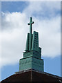
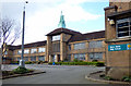
Notre Dame High School
This Modernist fleche with cross is a striking feature of the school building
Image: © Thomas Nugent
Taken: 19 Mar 2017
0.01 miles
2
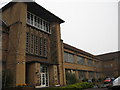
Notre Dame High School
Designed in 1938 by TS Cordiner and generally not included on tourist or architectural trails, Notre Dame High School is worth a visit by the discerning building-lover. The best example of functional Scandinavian influence in Glasgow.
Image: © Tom Morrison
Taken: 12 Dec 2009
0.01 miles
3
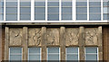
Notre Dame High School
The main door is surrounded by carved panels which depict the arts and sciences as well as Christian symbols. These ones are above the door.
Image: © Thomas Nugent
Taken: 19 Mar 2017
0.01 miles
4
Notre Dame High School
The main door is surrounded by carved panels which depict the arts and sciences as well as Christian symbols.
Image: © Thomas Nugent
Taken: 19 Mar 2017
0.01 miles
5
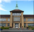
Notre Dame High School
The front of the school building and the playground.
Image: © Thomas Nugent
Taken: 19 Mar 2017
0.01 miles
6
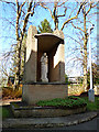
Notre Dame High School
The brick shrine to the Virgin Mary and Child Jesus at the rear of the school.
Image: © Thomas Nugent
Taken: 19 Mar 2017
0.03 miles
7
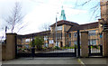
Notre Dame High School
A close view of the main gate, with the main school building beyond.
Image: © Thomas Nugent
Taken: 19 Mar 2017
0.04 miles
8
Notre Dame High School
The main gate of the school.
Image: © Thomas Nugent
Taken: 19 Mar 2017
0.04 miles
9
Notre Dame High School
This view shows the location of the school on a hilltop amongst the grand houses of the heart of the West End. This was the site of an observatory, which gave its name to Observatory Road, from where this photo was taken.
Image: © Thomas Nugent
Taken: 19 Mar 2017
0.05 miles
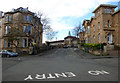
10
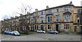
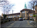
Observatory Road and Marchmount Terrace
Category B Listed http://portal.historicenvironment.scot/designation/LB32565 terraced houses. Viewed across Dundonald Road.
Image: © Thomas Nugent
Taken: 19 Mar 2017
0.08 miles