IMAGES TAKEN NEAR TO
Hamilton Drive, GLASGOW, G12 8DR
Introduction
This page details the photographs taken nearby to Hamilton Drive, G12 8DR by members of the Geograph project.
The Geograph project started in 2005 with the aim of publishing, organising and preserving representative images for every square kilometre of Great Britain, Ireland and the Isle of Man.

There are currently over 7.5m images from over14,400 individuals and you can help contribute to the project by visiting https://www.geograph.org.uk
Image Map
Images are licensed for reuse under creativecommons.org/licenses/by-sa/2.0
Notes
- Clicking on the map will re-center to the selected point.
- The higher the marker number, the further away the image location is from the centre of the postcode.
Image Listing (317 Images Found)
Images are licensed for reuse under creativecommons.org/licenses/by-sa/2.0
Image
Details
Distance
1
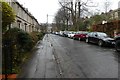
Hamilton Drive
Looking along Hamilton Drive. This road is split into two with traffic calming in the middle.
Image: © DS Pugh
Taken: 6 Apr 2019
0.01 miles
2
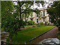
Terraced houses on Hamilton Drive, Hillhead
A long terrace of 34 houses in three sections, the two outer sections of 2 storeys of 1859 by Robert Crawford, the centre section 1869 by Alexander 'Greek' Thomson. This view shows part of the eastern section by Crawford Listed Category B http://portal.historicenvironment.scot/designation/LB32873 .
Image: © Alan Murray-Rust
Taken: 24 Jun 2019
0.03 miles
3
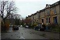
Hamilton Park Avenue
Seen from the junction of Hamilton Drive.
Image: © DS Pugh
Taken: 6 Apr 2019
0.04 miles
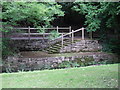
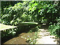
4
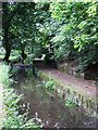
Old mill lade
By the River Kelvin in the west end of Glasgow.
Image: © Thomas Nugent
Taken: 12 Jul 2008
0.04 miles
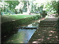
5
Old mill lade
By the River Kelvin in the west end of Glasgow.
Image: © Thomas Nugent
Taken: 12 Jul 2008
0.05 miles
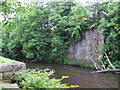
6
Remains of North Woodside Flint Mill
The mill opened in about 1765 originally as a barley mill and later used to produce flints and gunpowder. The mill was damaged during the blitz in the Second World War and closed.
Image: © Jonathan Thacker
Taken: 21 Jul 2013
0.05 miles
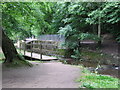
7
Remains of old bridge
Across the Kelvin from Image
Image: © Thomas Nugent
Taken: 12 Jul 2008
0.05 miles
8
Kelvin Walkway
With the old North Woodside flint mill lade in the foreground.
Image: © Thomas Nugent
Taken: 12 Jul 2008
0.05 miles
9
Mill Race, former North Woodside Flint Mill
The mill opened in about 1765 originally as a barley mill and later used to produce flints and gunpowder. The mill was damaged during the blitz in the Second World War and closed.
Image: © Jonathan Thacker
Taken: 21 Jul 2013
0.06 miles
10
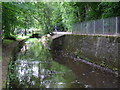
Old mill lade
By the River Kelvin. The Kelvin Walkway is to the right. The lade provided water to the ruined North Woodside flint mill.
Image: © Thomas Nugent
Taken: 12 Jul 2008
0.06 miles