IMAGES TAKEN NEAR TO
Addison Road, GLASGOW, G12 0TT
Introduction
This page details the photographs taken nearby to Addison Road, G12 0TT by members of the Geograph project.
The Geograph project started in 2005 with the aim of publishing, organising and preserving representative images for every square kilometre of Great Britain, Ireland and the Isle of Man.

There are currently over 7.5m images from over14,400 individuals and you can help contribute to the project by visiting https://www.geograph.org.uk
Image Map
Images are licensed for reuse under creativecommons.org/licenses/by-sa/2.0
Notes
- Clicking on the map will re-center to the selected point.
- The higher the marker number, the further away the image location is from the centre of the postcode.
Image Listing (131 Images Found)
Images are licensed for reuse under creativecommons.org/licenses/by-sa/2.0
Image
Details
Distance
1
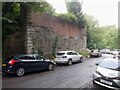
Bridge abutment
The abutment on the north side of Ford Road for the bridge which once carried the Glasgow Central Railway. Kirklee Station was just to the north of it. The platforms extended over the bridge and the infilling by bricks clearly shows where the trackbed was in relation to the platforms.
The line opened in 1894 and closed to all traffic in 1964.
Image: © Richard Sutcliffe
Taken: 13 Aug 2024
0.04 miles
2
Bridge abutment, Ford Road
Carried the Glasgow Central Railway. Opened in 1896 and finally closed in 1964, passenger services having ceased in 1939.
Image: © Jonathan Thacker
Taken: 15 Jul 2015
0.04 miles
3
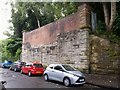
Bridge abutment
The abutment on the south side of Ford Road for the bridge which once carried the Glasgow Central Railway. Kirklee Station was just to the north of it. The platforms extended over the bridge and the infilling by bricks clearly shows where the trackbed was in relation to the platforms.
The line opened in 1894 and closed to all traffic in 1964.
Image: © Richard Sutcliffe
Taken: 13 Aug 2024
0.04 miles
4
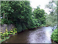
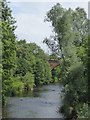
The River Kelvin
Looking upstream from the footbridge at the Ford Road entrance to Botanic Gardens Park.
Image: © Thomas Nugent
Taken: 4 Aug 2012
0.04 miles
5
Kirklee railway station (site), Glasgow
Opened in 1896 by the Glasgow Central Railway on the line from Newton to Maryhill and Dawsholm, this station closed in 1939. The line through the station closed in 1964.
View north towards Maryhill and Dawsholm - the line split just north of this station. Most of the site has been covered by new housing but the southern tips of the platforms were still visible when this image was taken.
Image: © Nigel Thompson
Taken: 29 Apr 2019
0.04 miles
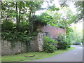
6
Ford Road and former support for railway bridge
Image: © David Smith
Taken: 19 Jul 2017
0.04 miles
7
Remains of the former Glasgow Central Railway line
Operated by the Caledonian Railway Company, the Glasgow Central Railway line https://en.wikipedia.org/wiki/Glasgow_Central_Railway ran from Dalmarnock in the south east to Maryhill in the north west. Much of the line is still in use today, but the section through and around the Botanic Gardens was closed in 1968. The remains of a bridge at Ford Road by the River Kelvin can be seen here.
Image: © Thomas Nugent
Taken: 19 Mar 2016
0.05 miles
8
River Kelvin upstream of Ha'penny Bridge
Image: © David Smith
Taken: 19 Jul 2017
0.05 miles
9
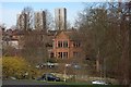
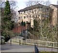
Housing
A view from The Botanic Gardens which shows the variety of housing there is in this part of Glasgow, from substantial villa to high rise flats.
Image: © Paul McIlroy
Taken: 18 Feb 2007
0.05 miles
10
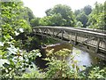
The Ha'penny bridge over the River Kelvin
When built, there was a toll of a halfpenny to cross. The bridge was destroyed in floods and replaced in 2002
Image: © David Smith
Taken: 19 Jul 2017
0.05 miles