IMAGES TAKEN NEAR TO
Winton Drive, GLASGOW, G12 0PZ
Introduction
This page details the photographs taken nearby to Winton Drive, G12 0PZ by members of the Geograph project.
The Geograph project started in 2005 with the aim of publishing, organising and preserving representative images for every square kilometre of Great Britain, Ireland and the Isle of Man.

There are currently over 7.5m images from over14,400 individuals and you can help contribute to the project by visiting https://www.geograph.org.uk
Image Map
Images are licensed for reuse under creativecommons.org/licenses/by-sa/2.0
Notes
- Clicking on the map will re-center to the selected point.
- The higher the marker number, the further away the image location is from the centre of the postcode.
Image Listing (44 Images Found)
Images are licensed for reuse under creativecommons.org/licenses/by-sa/2.0
Image
Details
Distance
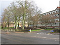
1
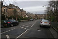
Winton Drive
Looking east, down the hill towards the River Kelvin. There are several speed bumps along this stretch of road.
Image: © Richard Sutcliffe
Taken: 24 Mar 2016
0.04 miles
2
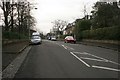
Winton Drive
Looking west, up the hill towards Cleveden Road.
Image: © Richard Sutcliffe
Taken: 24 Mar 2016
0.08 miles
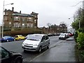
3
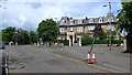
Roundabout on Cleveden Road
The fine building ahead is the former Westbourne School for Girls. Winton Drive leads off to the right.
Image: © Gordon Brown
Taken: 9 Jun 2019
0.08 miles
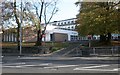
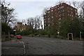
5
Cleveden Secondary School
The building straddles 2 squares with the entrance being in square NS5568.
The school is an amalgam of the former Cleveden and North Kelvinside Secondaries and the combined school came into being in 1998.
Image: © G Laird
Taken: 16 Jan 2010
0.12 miles
6
Contrasting architecture on Cleveden Road
A modern block of flats and a Victorian villa on Cleveden Road. The villa, at 16 Cleveden Road, dates from about 1883 and is a 'B' listed building.
The junction with Cleveden Drive is in the foreground.
Image: © Richard Sutcliffe
Taken: 24 Mar 2016
0.12 miles
7
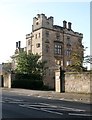
Kelvinside House
The address for this Category B listed building [http://portal.historicenvironment.scot/designation/LB32302] is 2 Beaconsfield Road, but this is the view of the property from Cleveden Road. At one stage a school, it is now divided into flats.
Image: © Richard Sutcliffe
Taken: 18 Oct 2018
0.13 miles
9
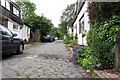
The Alley at Cleveden Gardens
This is the alley south of the houses at Cleveden Gardens
Image: © John Martin
Taken: 15 Jun 2002
0.14 miles
10
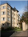
Westbourne Grange
Part of a development of 32 flats at 67 Cleveden Road.
Image: © Richard Sutcliffe
Taken: 18 Oct 2018
0.14 miles