IMAGES TAKEN NEAR TO
Grandtully Drive, GLASGOW, G12 0DP
Introduction
This page details the photographs taken nearby to Grandtully Drive, G12 0DP by members of the Geograph project.
The Geograph project started in 2005 with the aim of publishing, organising and preserving representative images for every square kilometre of Great Britain, Ireland and the Isle of Man.

There are currently over 7.5m images from over14,400 individuals and you can help contribute to the project by visiting https://www.geograph.org.uk
Image Map
Images are licensed for reuse under creativecommons.org/licenses/by-sa/2.0
Notes
- Clicking on the map will re-center to the selected point.
- The higher the marker number, the further away the image location is from the centre of the postcode.
Image Listing (46 Images Found)
Images are licensed for reuse under creativecommons.org/licenses/by-sa/2.0
Image
Details
Distance
1
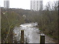
River Kelvin from Forth and Clyde aqueduct
This is to complement the first geograph for this square. Taken on the day the clocks went forward (where is spring!!) a day of heavy rain with the river in spate and cormorants resting on the old bridge piers
Image: © paul birrell
Taken: 26 Mar 2006
0.06 miles
3
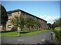
Fortingall Place flats
Built on the site of a 19thC paper mill beside the River Kelvin.
Image: © Jim Smillie
Taken: 9 Sep 2009
0.13 miles
4
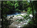
Weir: River Kelvin
On the river by the site of the former Kelvindale paper mill.
Image: © Jim Smillie
Taken: 9 Sep 2009
0.14 miles
5
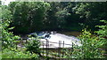
Weir on the River Kelvin near Queen Margaret Bridge
Just downstream from the canal aqueduct.
Image: © Gordon Brown
Taken: 9 Jun 2019
0.14 miles
6
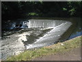
Weir on the River Kelvin
Near Wyndford.
Image: © Jonathan Thacker
Taken: 21 Jul 2013
0.14 miles
7
![Forth and Clyde Canal [43]](https://s3.geograph.org.uk/geophotos/06/24/97/6249703_3a2e0626_120x120.jpg)
Forth and Clyde Canal [43]
The weir on the river just downstream from the aqueduct.
The Kelvin Aqueduct carries the Forth & Clyde Canal over the River Kelvin. The aqueduct at some 400 feet in length was one of the largest built since Roman times when constructed in 1787-90 under the direction of engineer Robert Whitworth. Listed, category A, with details at: http://portal.historicenvironment.scot/designation/LB32316
The Forth and Clyde Canal was completed in 1790 and it provided a route for vessels between the Firth of Forth and the Firth of Clyde at the narrowest part (35 miles, 56km) of the Scottish Lowlands. Closed in 1963, the canal became semi-derelict. Millennium funds were used to regenerate the canal. The main line of the canal is a Scheduled Monument with details at: http://portal.historicenvironment.scot/designation/SM6773
Image: © Michael Dibb
Taken: 25 Jun 2019
0.14 miles
8
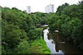
River Kelvin
Looking downstream from the Kelvin Aqueduct. The pillars look like the supports of a railway bridge, but none of the historic Ordnance Survey maps shows a bridge there.
Image: © Anne Burgess
Taken: 25 Jun 2019
0.15 miles
9
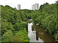
River Kelvin from the aqueduct
Looking down towards a weir; in between are the two piers of a former railway viaduct that crossed river on a skew angle.
Image: © Stephen Craven
Taken: 25 Jun 2019
0.15 miles
10

Kelvindale Buildings
These would appear to be connected with the former Kelvindale paper mill.
Image: © Jim Smillie
Taken: 9 Sep 2009
0.15 miles