IMAGES TAKEN NEAR TO
Beith Street, GLASGOW, G11 6QG
Introduction
This page details the photographs taken nearby to Beith Street, G11 6QG by members of the Geograph project.
The Geograph project started in 2005 with the aim of publishing, organising and preserving representative images for every square kilometre of Great Britain, Ireland and the Isle of Man.

There are currently over 7.5m images from over14,400 individuals and you can help contribute to the project by visiting https://www.geograph.org.uk
Image Map
Images are licensed for reuse under creativecommons.org/licenses/by-sa/2.0
Notes
- Clicking on the map will re-center to the selected point.
- The higher the marker number, the further away the image location is from the centre of the postcode.
Image Listing (454 Images Found)
Images are licensed for reuse under creativecommons.org/licenses/by-sa/2.0
Image
Details
Distance
1
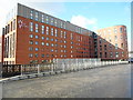
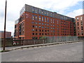
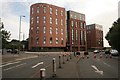
West Village
Student accommodation facing onto Benalder Street.
Image: © Richard Sutcliffe
Taken: 28 Feb 2017
0.01 miles
2
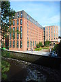
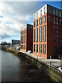
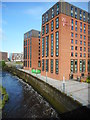
West Village and the River Kelvin
Student accommodation on the north bank of the River Kelvin. A lot of water is flowing down the river after high rainfall.
Image: © Richard Sutcliffe
Taken: 12 Aug 2019
0.01 miles
3
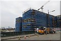
New flats, Benalder Road
Student accommodation under construction.
Image: © Richard Webb
Taken: 14 Mar 2015
0.01 miles
4
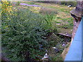
Site of Kelvin Hall Station
Only the platform survives. Viewed from the bridge at Benalder Street. See the station here Image
Image: © Thomas Nugent
Taken: 10 Oct 2010
0.01 miles
5
Partick Central / Kelvin Hall railway station (site), Glasgow
Opened in 1896 as "Partick Central "by the Lanarkshire and Dumbartonshire Railway, effectively part of the Caledonian Railway, on the line from Stobcross to Dumbarton, this station was renamed "Kelvin Hall" in 1959. It closed in 1964.
View west at the former entrance building, which had steps down to the platforms. The modern buildings stand across the site of the platforms. The gap in the old fencing shows the site of the road-level building.
Image: © Nigel Thompson
Taken: 29 Apr 2019
0.02 miles
6
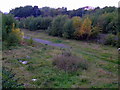
Former railway land
Site of the former Kelvin Hall railway station, by the River Kelvin, viewed from the bridge at Benalder Street. See the station here Image
Image: © Thomas Nugent
Taken: 10 Oct 2010
0.02 miles
7
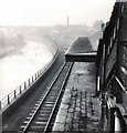
Kelvin Hall Station
Originally named Partick Central http://en.wikipedia.org/wiki/Partick_Central_railway_station the station was renamed Kelvin Hall in 1959.
As part of the Lanarkshire and Dunbartonshire Railway, it opened in 1896. It closed to passengers in 1964 and to freight in 1978. The station was demolished in 2007. Only the platform was still just visible in 2010 Image
It is not be confused with the subway station of the same name, Image
Image: © Gerald England
Taken: Unknown
0.02 miles
8
West Village and the River Kelvin
Student accommodation on the north bank of the River Kelvin.
Image: © Richard Sutcliffe
Taken: 28 Feb 2017
0.02 miles
9
West Village and the River Kelvin
Student accommodation on the north bank of the River Kelvin. A lot of water is flowing down the river after high rainfall.
Image: © Richard Sutcliffe
Taken: 12 Aug 2019
0.02 miles
10
West Village, Beith Street
New student accommodation in Glasgow's west end. Photographed from Benalder Street, while it was closed off due to the partial collapse of a building close to Dumbarton Road.
Image: © Richard Sutcliffe
Taken: 24 Aug 2016
0.02 miles